
Wistaria Tea House
| Wistaria Tea House 紫藤廬 | |
|---|---|
 | |
 | |
| Restaurant information | |
| Established | 1981 |
| Owner(s) | Wistaria Cultural Association |
| Street address | Daan, Taipei, Taiwan |
The Wistaria Tea House (Chinese: 紫藤廬; pinyin: Zǐténg Lú), the Wisteria House, or Wistaria House is a historical teahouse in Daan District, Taipei, Taiwan. The establishment is situated in a Japanese-style wooden house built in the 1920s on Xinsheng South Road. The teahouse is named after the three wisteria vines planted in the front courtyard forming a shaded area leading to the entrance of the building. The teahouse, with its circa 1930s decor, was reopened to much fanfare after a long needed renovation in 2008.[1]
The teahouse was used during the filming of Eat Drink Man Woman.[citation needed]
History[edit]
The house served as a residence for the Governor-General of Taiwan under Japanese rule prior to 1945 and became government dormitories under the Republic of China administration in 1950. The building became a teahouse and gained its present name in 1981 and was meeting place for political dissidents such as Lei Chen (雷震) fighting for a democratic Taiwan during the 1980s. Since then, Wisteria House has been and continues to be a favored meeting place for Taipei literati, artists, and academics. It has since been designated as a historic monument by the Taipei government in 1997 and operation of the teahouse was turned over to the Wistaria Cultural Association by the Taipei City Cultural Bureau.[2][3]
Gallery[edit]
-
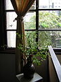 View from the second floor
 -
 Trellis supporting the wisteria vines
 -
 Plaque describing the Wisteria Tea House


References[edit]
- ^ 董, 曉 (2008-11-16), 紫藤廬茶館:清靜優雅中見證臺灣社會變遷, 新華網, archived from the original on June 11, 2011
- ^ Lu, Fiona (2009-10-08), Savoring tea and Taiwan's democratization history at Wistaria Tea House, Culture Taiwan
- ^ Wistaria Cultural Association, Wistaria: A Taipei Historical Heritage Site