
File:Geschichte Graubuenden.png

Size of this preview: 640 × 599 pixels. Other resolutions: 256 × 240 pixels | 820 × 768 pixels | 1,093 × 1,024 pixels | 2,000 × 1,873 pixels.
Original file (2,000 × 1,873 pixels, file size: 504 KB, MIME type: image/png)
| This is a file from the Wikimedia Commons. Information from its description page there is shown below. Commons is a freely licensed media file repository. You can help. |
Summary
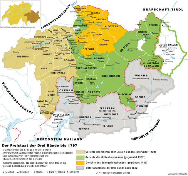
| Description | Historische Karte zur Geschichte des Freistaats der Drei Bünde (Graubünden) |
| Date | |
| Source | own work, basiert auf: Adolf Gasser und Ernst Keller, Historische Karte zur territorialen Entwicklung der Schweizerischen Eidgenossenschaft 1291–1797. o.O. 1932. |
| Author | Marco Zanoli (sidonius 11:39, 13 June 2006 (UTC)) |
| Other versions |
   |
Licensing
You may use my work outside wikipedia for free as long as you name me as the author. If you would like to use my work in a print medium, please send me a specimen copy.
Contact me if you have questions regarding the license or if you want individual changes to the map (marco.zanoli at hotmail.ch). This file is licensed under the Creative Commons Attribution-Share Alike 4.0 International license. Attribution: Marco Zanoli
|
File history
Click on a date/time to view the file as it appeared at that time.
| Date/Time | Thumbnail | Dimensions | User | Comment | |
|---|---|---|---|---|---|
| current | 22:18, 22 March 2013 | | 2,000 × 1,873 (504 KB) | Kopiersperre | OptiPNG |
| 20:57, 6 October 2012 |  | 2,000 × 1,873 (777 KB) | Sidonius | - einige Korrekturen, bes. Hauptorte der Gerichtsgemeinden - Grafisch leicht überarbeitet - Übersichtskarte der Eidgenossenschaft eingefügt - Ortschaftsmarkierungen vereinheitlicht, Schriftgrössen skaliert | |
| 02:16, 28 June 2012 |  | 1,973 × 1,842 (977 KB) | Ras67 | cropped | |
| 04:41, 4 July 2010 |  | 2,000 × 1,866 (982 KB) | DcoetzeeBot | Remove watermark, add author and license data to image metadata, decrease filesize with pngcrush | |
| 09:28, 7 August 2006 |  | 2,000 × 1,866 (1.18 MB) | Sidonius | ||
| 16:58, 16 June 2006 |  | 2,000 × 1,866 (1.17 MB) | Sidonius | ||
| 13:57, 13 June 2006 |  | 1,514 × 1,410 (530 KB) | Sidonius | ||
| 11:39, 13 June 2006 |  | 1,892 × 1,765 (699 KB) | Sidonius | {{Information| |Description=Historische Karte zur Geschichte des Freistaats der Drei Bünde (Graubünden) |Source=own work, basiert auf: Adolf Gasser und Ernst Keller, Historische Karte zur territorialen Entwicklung der Schweizerischen |
File usage
The following pages on the English Wikipedia use this file (pages on other projects are not listed):
Global file usage
The following other wikis use this file:
- Usage on als.wikipedia.org
- Usage on cs.wikipedia.org
- Usage on de.wikipedia.org
- Usage on es.wikipedia.org
- Usage on fi.wikipedia.org
- Usage on lmo.wikipedia.org
- Usage on nl.wikipedia.org
- Usage on nn.wikipedia.org
- Usage on no.wikipedia.org
- Usage on rm.wikipedia.org
- Usage on sl.wikipedia.org
- Usage on sv.wikipedia.org