
Portal:Africa

.svg)
Africa is the world's second largest and second-most populous continent after Asia. At about 30.3 million km2 (11.7 million square miles) including adjacent islands, it covers 20% of Earth's land area and 6% of its total surface area. With 1.4 billion people0 as of 2021, it accounts for about 18% of the world's human population. Africa's population is the youngest amongst all the continents; the median age in 2012 was 19.7, when the worldwide median age was 30.4. Despite a wide range of natural resources, Africa is the least wealthy continent per capita and second-least wealthy by total wealth, ahead of Oceania. Scholars have attributed this to different factors including geography, climate, lack of democracy, tribalism, corruption, colonialism, the Cold War, and neocolonialism. Despite this low concentration of wealth, recent economic expansion and the large and young population make Africa an important economic market in the broader global context.
Africa straddles the equator and the prime meridian. It is the only continent to stretch from the northern temperate to the southern temperate zones. The majority of the continent and its countries are in the Northern Hemisphere, with a substantial portion and a number of countries in the Southern Hemisphere. Most of the continent lies in the tropics, except for a large part of Western Sahara, Algeria, Libya and Egypt, the northern tip of Mauritania, and the entire territories of Morocco, Ceuta, Melilla, and Tunisia which in turn are located above the tropic of Cancer, in the northern temperate zone. In the other extreme of the continent, southern Namibia, southern Botswana, great parts of South Africa, the entire territories of Lesotho and Eswatini and the southern tips of Mozambique and Madagascar are located below the tropic of Capricorn, in the southern temperate zone.
Africa is highly biodiverse; it is the continent with the largest number of megafauna species, as it was least affected by the extinction of the Pleistocene megafauna. However, Africa also is heavily affected by a wide range of environmental issues, including desertification, deforestation, water scarcity and pollution. These entrenched environmental concerns are expected to worsen as climate change impacts Africa. The UN Intergovernmental Panel on Climate Change has identified Africa as the continent most vulnerable to climate change.
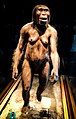
The history of Africa is long, complex, and varied, and has often been under-appreciated by the global historical community. Africa, particularly Eastern Africa, is widely accepted as the place of origin of humans and the Hominidae clade (great apes). The earliest hominids and their ancestors have been dated to around 7 million years ago, including Sahelanthropus tchadensis, Australopithecus africanus, A. afarensis, Homo erectus, H. habilis and H. ergaster—the earliest Homo sapiens (modern human) remains, found in Ethiopia, South Africa, and Morocco, date to circa 233,000, 259,000, and 300,000 years ago, respectively, and Homo sapiens is believed to have originated in Africa around 350,000–260,000 years ago. Africa is also considered by anthropologists to be the most genetically diverse continent as a result of being the longest inhabited. (Full article...)
Selected article –
Featured pictures –
-
 Photograph credit: Charles J. SharpThe sable antelope (Hippotragus niger) is an antelope which inhabits wooded savanna in eastern and southern Africa, from the south of Kenya to South Africa, with a separate population in Angola. The species is sexually dimorphic, with the male heavier and about one-fifth taller than the female. It has a compact and robust build, characterized by a thick neck and tough skin, and both sexes have ringed horns which arch backward. The sable antelope has four subspecies.
This picture shows an adult male common sable antelope (H. n. niger) in the Tswalu Kalahari Reserve, South Africa. -
 Photo credit: LaitcheThe Rose Geranium (Pelargonium graveolens) is a plant indigenous to various parts of southern Africa, and in particular South Africa. This specific species has great importance in the perfume industry. Its cultivars have a wide variety of smells, including rose, citrus, mint, coconut and nutmeg, as well as various fruits.
 -
 Photograph: Muhammad Mahdi KarimAdansonia digitata is a sub-Saharan African species of baobab tree. The genus, scientifically known as Adansonia, consists of nine species native to Madagascar, Africa, Arabia and Australia, and can reach heights of 5 to 30 m (16 to 98 ft) with trunk diameters of 7 to 11 m (23 to 36 ft).
 -
 Photograph: Sathyan VelumaniThe Larabanga Mosque was built in the Sudanese architectural style in the village of Larabanga, Ghana. It is the oldest mosque in the country and one of the oldest in West Africa, and has been called the "Mecca of West Africa". It has undergone restoration several times since it was founded. The World Monuments Fund has contributed substantially to its restoration, and lists it as one of the 100 most endangered sites.
 -
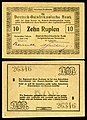 Banknote design credit: Deutsch-Ostafrikanische Bank; photographed by Andrew ShivaThe rupie was the unit of currency of German East Africa between 1890 and 1916. During World War I, the colony was cut off from Germany as a result of a wartime blockade and the colonial government needed to create an emergency issue of banknotes. Paper made from linen or jute was initially used, but because of wartime shortages, the notes were later printed on commercial paper in a variety of colours, wrapping paper, and in one instance, wallpaper. This twenty-rupie banknote was issued in 1915, and is now part of the National Numismatic Collection at the Smithsonian Institution.
Other denominations:
'"`UNIQ--templatestyles-00000013-QINU`"' -

Mikumi National Park Credit: Muhammad Mahdi Karim
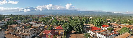
Moshi is a Tanzanian town with a population of 144,739 (2002 census) in Kilimanjaro Region. The town is situated on the lower slopes of Mt Kilimanjaro, a volcanic mountain that is the highest mountain in Africa. Moshi is home to the Chagga and Maasai tribes and lies on the A 23 Arusha-Himo east-west road connecting Arusha and Mombasa, Kenya. Just to the east of Moshi is the intersection with the B 1 north-south road eventually connecting with Tanga and Dar es Salaam. -
 Banknote: Swakopmund Bookshop (courtesy of the National Numismatic Collection, National Museum of American History)The South West African mark was a temporary currency issued in South West Africa between 1916 and 1918 as part of the South West Africa campaign. Issued after the conquest of German South West Africa by South Africa, notes were denominated in marks and pfennig, as with the withdrawn German South West African Mark. Many institutions issued banknotes; this two-mark note was issued by the Swakopmund Bookshop. The South-West African mark was replaced in 1918 by the South African pound.
 -
 Eswatini, formerly known as Swaziland, is a landlocked country in Southern Africa. The government is an absolute monarchy, the last of its kind in Africa, and the country has been ruled by King Mswati III since 1986. One of the country's important cultural events is Umhlanga, the reed-dance festival, held in August or September each year. This photograph shows Princess Sikhanyiso Dlamini, the eldest daughter of Mswati III, at the 2006 festival.
 -

Male lion and cub eating a cape buffalo in Northern Sabi Sand, South Africa Photo credit: Luca Galuzzi
The lion (Panthera leo) is a mammal of the family Felidae and one of four "big cats" in the genus Panthera. The lion is the second largest feline species, after the tiger. The male lion, easily recognized by his mane, weighs between 150 and 250 kg (330–500 lb). Females range 120–150 kg (260–330 lb). In the wild, lions live for around 10–14 years, while in captivity they can live over 20 years. Though they were once found throughout much of Africa, Asia and Europe, lions presently exist in the wild only in Africa and India. They enjoy hot climates, and hunt in groups. -
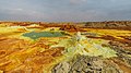 Photograph credit: Alexander SavinDallol is a cinder-cone volcano in the Danakil Depression, northeast of the Erta Ale Range in Ethiopia. The area lies up to 120 m (390 ft) below sea level, and has been repeatedly flooded in the past when waters from the Red Sea have inundated it. The Danakil Depression is one of the hottest places on Earth, and the evaporation of seawater after these flooding episodes produced thick deposits of salt, as seen in this landscape. The deposits at Dallol include significant quantities of the carbonate, sulfate and chloride salts of sodium, potassium, calcium and magnesium. Hot springs discharge brine to form the blueish ponds, and small, temporary geysers produce cones of salt.
 -

Tanzanians in Dar es Salaam protesting the 2008-2009 Gaza bombardment by Israel. Credit: Muhammad Mahdi Karim
Tanzanians in Dar es Salaam protesting the 2008-2009 Gaza bombardment by Israel. International reaction to the conflict was also notable in the level of civilian demonstrations all around the world, which in many cases displayed sentiment significantly different from the official government line. -
 Photo: NASAA composite satellite image of the geography of Africa, the Earth's second-largest continent, and its adjacent islands. Separated from Europe by the Mediterranean Sea and from much of Asia by the Red Sea, Africa is joined to Asia at its northeast extremity by the Isthmus of Suez. For geopolitical purposes, the Sinai Peninsula – east of the Suez Canal – is often considered part of Africa, although geographically it belongs in Asia. Africa can be divided into a number of geographic zones: The Atlas Mountains in the north, the Sahara, the coastal plains, and the inner plateaus.
 -
 Photo: William WarbyPortrait of a Maasai woman, with shaved head, stretched earlobes, and beaded adornments, typical of the Maasai culture. The Maasai are a Nilotic ethnic group of semi-nomadic people located in Kenya and northern Tanzania. They are among the best known of African ethnic groups, due to their distinctive customs and dress and residence near the many game parks of East Africa. Their primary language Maa (ɔl Maa) is a member of the Nilo-Saharan language family that is related to Dinka and Nuer.
 -
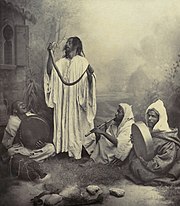
Snake charmers Credit: Tancrède Dumas
Snake charming is the practice of apparently hypnotising a snake by simply playing an instrument. A typical performance may also include handling the snakes or performing other seemingly dangerous acts. The practice is most common in India, though it is also practiced in the North African countries of Egypt, Morocco, and Tunisia. This photo depicts snake charmers in late 19th-century Morocco. -
 Photograph credit: Charles James SharpThe roan antelope (Hippotragus equinus) is a species of savanna antelope found in western, central and southern Africa. Named for its reddish-brown coat, it has a black face with white patches around the eyes and the mouth, and a short erect mane of greyish brown hair extending from the back of the neck to the rump. This roan antelope, of the subspecies H. e. koba, was photographed in Senegal; the subspecies's range extends from Senegal to Benin in western Africa.
 -
 Photograph: Poco a pocoPanoramic view of the Amphitheatre of El Jem, an archeological site in the city of El Djem, Tunisia. The amphitheatre, one of the best-preserved Roman ruins and a UNESCO World Heritage Site since 1979, was built around 238 AD, when modern Tunisia belonged to the Roman province of Africa. It is the third-biggest amphitheatre in the world, with axes of 148 m (486 ft) and 122 m (400 ft) and a seating capacity of 35,000, unique in Africa.
 -
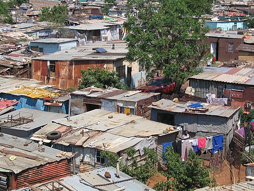
Shanty town housing in Soweto, South Africa Credit: User:Matt-80Soweto (/səˈwɛtoʊ, -ˈweɪt-, -ˈwiːt-/) is a township of the City of Johannesburg Metropolitan Municipality in Gauteng, South Africa, bordering the city's mining belt in the south. Its name is an English syllabic abbreviation for South Western Townships. Formerly a separate municipality, it is now incorporated in the City of Johannesburg Metropolitan Municipality, Suburbs of Johannesburg. -

Bareina Credit: Ferdinand Reus
Bareina is a Bedouin village and rural commune in the Trarza region of south-western Mauritania. As of 2000 it had a population of 14,987. This photo is a view of the village just minutes before rain started. -
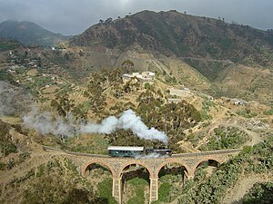
Eritrean Railway Credit: User:Tivedshambo
The Eritrean Railway, the only railway system in Eritrea, was constructed between 1887 and 1932 by the Kingdom of Italy for the Italian colony of Eritrea, and connected the port of Massawa with Bishia near the Sudan border. The railway is narrow gauge and is slowly being rebuilt after the devastation wreaked upon it during the war of independence. It still manages to operate, however, despite its newest equipment being nearly fifty years old, with most of it predating World War II. It is one of the few railway systems still in existence (excluding tourist railways) using equipment like the 1930s Italian-built 'Littorina' railcars behind 1930s-vintage Mallet steam locomotives.
_adult_male.jpg)


.jpg)


.jpg)


.jpg)


.jpg)


Did you know (auto-generated) -

- ... that one way to tell the African dusky flycatcher apart from the ashy flycatcher is that the former is "cuter"?
- ... that whilst serving as the Central African ambassador in Paris, Sylvestre Bangui held a press conference confirming that his government had massacred children and resigned?
- ... that Bill Pinkney was the first African American to sail around the world solo via the Cape of Good Hope and Cape Horn?
- ... that after being denied admission to Memphis State University because of her race, Miriam DeCosta-Willis went on to become the university's first African-American professor?
- ... that after the 2020 Summer Olympics were postponed, South African artistic gymnast Caitlin Rooskrantz livestreamed the routine she was going to perform?
- ... that the African Society of Human Genetics was established so that more human genetics and genomics research could be done by African scientists in Africa?
Categories

Selected biography –

Francis Kwame Nkrumah (21 September 1909 – 27 April 1972) was a Ghanaian politician, political theorist, and revolutionary. He served as Prime Minister of the Gold Coast from 1952 until 1957, when it gained independence from Britain. He was then the first Prime Minister and then the President of Ghana, from 1957 until 1966. An influential advocate of Pan-Africanism, Nkrumah was a founding member of the Organization of African Unity and winner of the Lenin Peace Prize from the Soviet Union in 1962.
After twelve years abroad pursuing higher education, developing his political philosophy, and organizing with other diasporic pan-Africanists, Nkrumah returned to the Gold Coast to begin his political career as an advocate of national independence. He formed the Convention People's Party, which achieved rapid success through its unprecedented appeal to the common voter. He became Prime Minister in 1952 and retained the position when Ghana declared independence from Britain in 1957. In 1960, Ghanaians approved a new constitution and elected Nkrumah President. (Full article...)Selected country –
 |
 |
||

| |||
Mozambique, officially the Republic of Mozambique (Portuguese: República de Moçambique), is a country in southeastern Africa bordered by the Indian Ocean to the east, Tanzania to the north, Malawi and Zambia to the northwest, Zimbabwe to the west and Eswatini and South Africa to the southwest. It was explored by Vasco da Gama in 1498 and colonized by Portugal in 1505.
The north-central provinces of Zambezia and Nampula are the most populous, containing about 45% of the population. The estimated four million Makua are the dominant group in the northern part of the country; the Sena and Shona (mostly Ndau) are prominent in the Zambezi valley, and the Shangaan (Tsonga) dominate in southern Mozambique.
Portuguese is the official and most widely spoken language, spoken by 40% of the population. Most educated Mozambicans speak English, which is used in schools and business as a second or third language. (Read more...)
Selected city –

Port Harcourt (Pidgin: Po-ta-kot or Pi-ta-kwa) is the capital and largest city of Rivers State in Nigeria. It is the fifth most populous city in Nigeria after Lagos, Kano, Ibadan and Benin. It lies along the Bonny River and is located in the oil rich Niger Delta. As of 2023, Port Harcourt's urban population is estimated at 3,480,000. The population of the metropolitan area of Port Harcourt is almost twice its urban area population with a 2015 United Nations estimate of 2,344,000. In 1950, the population of Port Harcourt was 59,752. Port Harcourt has grown by 150,844 since 2015, which represents a 4.99% annual change.
The area that became Port Harcourt in 1912 was before that of a farmland of people of Rebisi (Ikwerre). The colonial administration of Nigeria created the port to export coal from the collieries of Enugu located 243 kilometres (151 mi) north of Port Harcourt, to which it was linked by a railway called the Eastern Line, also built by the British. (Full article...)In the news
- 12 February 2024 –
- Two boats collide on the Congo River near Kinshasa, Democratic Republic of the Congo; with the death toll remains unclear. (AP)
- 11 February 2024 – 2023 Africa Cup of Nations
- In association football, hosts Ivory Coast win their third Africa Cup of Nations by defeating Nigeria 2–1 in the final. Sébastien Haller scores the winning goal in the 81st minute. (The Guardian)
- 10 February 2024 – Somali civil war
- Four Emirati soldiers and a Bahraini military officer are killed, while ten other people are injured, when a soldier opens fire at a military base in Mogadishu, Somalia, before being killed in the ensuing shootout. Al-Shabaab claims responsibility. (AP)
- 10 February 2024 –
- A Eurocopter EC130 helicopter crashes near Nipton, California, United States, killing all the six people on board, including Nigerian banker Herbert Wigwe. (CBS News)
- 10 February 2024 – 2023–2024 Senegalese protests
- Violent protests occur in Senegal following an announcement by President Macky Sall that presidential elections have been delayed from February 25 to December 15. (Sky News)
- 9 February 2024 –
- At least 18 people are killed during a collision between a bus and a truck on a road in Kinshasa, Democratic Republic of the Congo. (AP)
Updated: 16:33, 14 February 2024
General images -
-

-

-
 Ruby, Egyptian singer performing (from Culture of Africa)
 -
-
 Carthaginian Empire in 323 BC (from History of Africa)
 -

-

-
 Tingatinga is one of the most widely represented forms of paintings in Tanzania, Kenya and neighbouring countries (from Culture of Africa)
 -
 Fufu (right) is a staple meal in West Africa and Central Africa. It is usually served with some peanut soup. (from Culture of Africa)
 -
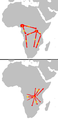
 Pre-Neolithic and Neolithic migration events in Africa. (from History of Africa)
 -
 Contemporary political map of Africa (Includes Sub-Saharan Africa and North Africa) (from History of Africa)
 -
 Dates of independence of African countries (from History of Africa)
 -
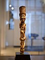
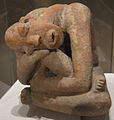 Terracotta sculpture, 13th c.; the raised marks and indentations on the back of this hunched Djenné figure may represent disease or, more likely, scarification patterns. The facial expression and pose could depict an individual in mourning or in pain (from History of Africa)
 -
 Vegetation and water bodies in early Holocene (top), between about 12,000 and 7,000 years ago, and Eemian (bottom) (from History of Africa)
 -
1 = 2000–1500 BC origin
2 = c. 1500 BC first dispersal
2.a = Eastern Bantu
2.b = Western Bantu
3 = 1000–500 BC Urewe nucleus of Eastern Bantu
4–7 = southward advance
9 = 500–1 BC Congo nucleus
10 = AD 1–1000 last phase (from History of Africa) -
 A Yombe sculpture (Louvre, Paris) (from Culture of Africa)
 -
 Gateway to the Castle of Good Hope in South Africa (from Culture of Africa)
 -
 The Great Pyramids of Giza, Egypt (from Culture of Africa)
 -
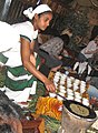 An Ethiopian woman preparing Ethiopian coffee at a traditional ceremony. She roasts, crushes, and brews the coffee on the spot. (from Culture of Africa)
 -
 Map of ancient Egypt, showing major cities and sites of the Dynastic period (c. 3150 BC to 30 BC) (from History of Africa)
 -
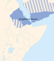 The Kingdom of Aksum in the 6th century AD. (from History of Africa)
 -
 9th-century bronze staff head in form of a coiled snake, Igbo-Ukwu, Nigeria (from History of Africa)
 -
 Sudan basket-tray, tabar of weaved natural plant fiber, in different colors (from Culture of Africa)
 -
 Kenyan boys and girls performing a traditional folklore dance (from Culture of Africa)
 -

-
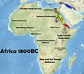 Map showing the states, people, and material cultures of the African continent c. 1800 BC, but missing the Kintampo civilisation and Tichitt culture in West Africa. (from History of Africa)
 -
 A terra-cotta head sculpture (1100-1500) of the Yoruba, showing extraordinary naturalism. This head represents the oni or king of Ife. (from Culture of Africa)
 -

-
 Traditional male dancers from Northern Nigeria (from Culture of Africa)
 -
 Egyptian singer Umm Kulthum, one of the most iconic singers in African history (from Culture of Africa)
 -

-
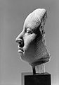
 Reconstruction of "Lucy" (from History of Africa)
 -
 Potjiekos is a traditional Afrikaner stew made with meat and vegetables and cooked over coals in cast-iron pots. (from Culture of Africa)
 -
 Maasai wearing traditional clothes named Matavuvale while performing Adumu, a traditional dance (from Culture of Africa)
 -

-
 Areas controlled by European powers in 1939. British (red) and Belgian (marroon) colonies fought with the Allies. Italian (light green) with the Axis. French colonies (dark blue) fought alongside the Allies until the Fall of France in June 1940. Vichy was in control until the Free French prevailed in late 1942. Portuguese (dark green) and Spanish (yellow) colonies remained neutral. (from History of Africa)
 -
-
 Ancient Kano City Walls, Nigeria (from Culture of Africa)


_5.png)
.jpg)


.jpg)


.jpg)


Africa topics
More did you know –
- ... that Liberia College in the country of Liberia was authorized by the legislature in 1851, but did not start classes until 1863?
- ... that the forced removal of 700,000 people from slums in Zimbabwe in 2005 was called "a crime against humanity" by the UN?
- ... that the supreme god of the southern African Bushmen is Cagn, a trickster who shapeshifts into a praying mantis?
- ... that Bahá'í Faith in Niger began during a period of wide scale growth in the religion across Sub-Saharan Africa near the end of its colonial period?
Related portals
Major Religions in Africa
North Africa
West Africa
Central Africa
East Africa
Southern Africa
Associated Wikimedia
The following Wikimedia Foundation sister projects provide more on this subject:
-
 Commons
Free media repository -
 Wikibooks
Free textbooks and manuals -
 Wikidata
Free knowledge base -
 Wikinews
Free-content news -
 Wikiquote
Collection of quotations -
 Wikisource
Free-content library -
 Wikispecies
Directory of species -
 Wikiversity
Free learning tools -
 Wikivoyage
Free travel guide -
 Wiktionary
Dictionary and thesaurus


