
File:Agriates.png

Size of this preview: 800 × 528 pixels. Other resolutions: 320 × 211 pixels | 640 × 423 pixels | 1,024 × 676 pixels | 1,280 × 845 pixels | 1,655 × 1,093 pixels.
Original file (1,655 × 1,093 pixels, file size: 2.63 MB, MIME type: image/png)
| This is a file from the Wikimedia Commons. Information from its description page there is shown below. Commons is a freely licensed media file repository. You can help. |
| Description |
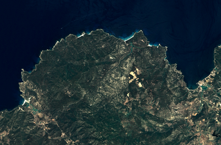
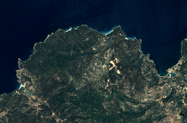
English: Agriates region, located on the north of Corsica (France). This satellite view was acquired by Landsat 7. The city of Saint-Florent is visible on the east.
Français : La micro-région des Agriates, située au nord de la Corse, vue par le satellite Landsat 7. On peut voir à droite la ville de Saint-Florent. |
||
| Date | |||
| Source | |||
| Author | Corsica (Landsat 7) - high definition.png: NASA/USGS, Telperion | ||
| Other versions |
|
||
| Other informations |
|
.png)
| Object location | | View this and other nearby images on: OpenStreetMap |
|---|
| This file is in the public domain in the United States because it was solely created by NASA. NASA copyright policy states that "NASA material is not protected by copyright unless noted". (See Template:PD-USGov, NASA copyright policy page or JPL Image Use Policy.) | ||
 |
Warnings:
|
This work is based on a work in the public domain. It has been digitally enhanced and/or modified. This derivative work has been (or is hereby) released into the public domain by its author, Telperion. This applies worldwide.
In some countries this may not be legally possible; if so: |
| Annotations | This image is annotated: View the annotations at Commons |

_-_high_definition.png)
File history
Click on a date/time to view the file as it appeared at that time.
| Date/Time | Thumbnail | Dimensions | User | Comment | |
|---|---|---|---|---|---|
| current | 13:54, 25 September 2011 | | 1,655 × 1,093 (2.63 MB) | Telperion | {{Information |Description ={{en|1=Agriates region, located on the north of Corsica (France). This satellite view was acquired by Landsat 7. The city of Saint-Florent i |
File usage
The following pages on the English Wikipedia use this file (pages on other projects are not listed):
Global file usage
The following other wikis use this file:
- Usage on fr.wikipedia.org