
File:All Saints Church - geograph.org.uk - 1232337.jpg
No higher resolution available.
All_Saints_Church_-_geograph.org.uk_-_1232337.jpg (640 × 426 pixels, file size: 80 KB, MIME type: image/jpeg)
| This is a file from the Wikimedia Commons. Information from its description page there is shown below. Commons is a freely licensed media file repository. You can help. |
Summary
| Description |
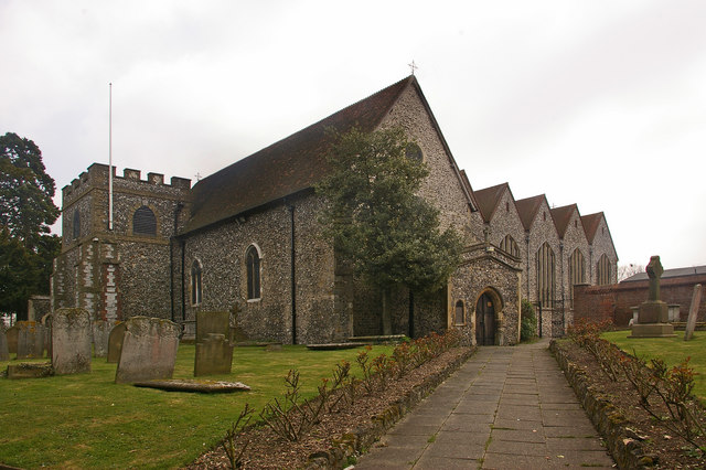
English: All Saints Church This Grade B listed church originally dates from the 12th century, although there are indications of an earlier building here. A tower was added in the 13th century and a porch in the 14th century. For many years it had a taller tower, but this was severely damaged by a storm in 1771, and the subsequent rebuilding was of this shorter castellated version, topped with a steeple. However in 1809 the steeple was struck by lightning and caught fire. It was not replaced, resulting in the present profile of a tower shorter than the surrounding roof.
In 1957, following demolition of Bark Hart House, a Tudor house to the south of the church where Elizabeth I had once stayed, the church was extended over part of the vacated land (the extension can be seen to the right of the photo). For listing particulars see http://www.heritagegateway.org.uk/Gateway/Results_Single.aspx?uid=358379&resourceID=5 |
| Date | |
| Source | From geograph.org.uk |
| Author | Ian Capper |
| Attribution (required by the license) | Ian Capper / All Saints Church / |
| Camera location | | View this and other nearby images on: OpenStreetMap |
|---|
_heading:157.00&language=en)
| Object location | | View this and other nearby images on: OpenStreetMap |
|---|
_heading:157.00&language=en)
Licensing

|
This image was taken from the Geograph project collection. See this photograph's page on the Geograph website for the photographer's contact details. The copyright on this image is owned by Ian Capper and is licensed for reuse under the Creative Commons Attribution-ShareAlike 2.0 license.
|
This file is licensed under the Creative Commons Attribution-Share Alike 2.0 Generic license.
Attribution: Ian Capper
- You are free:
- to share – to copy, distribute and transmit the work
- to remix – to adapt the work
- Under the following conditions:
- attribution – You must give appropriate credit, provide a link to the license, and indicate if changes were made. You may do so in any reasonable manner, but not in any way that suggests the licensor endorses you or your use.
- share alike – If you remix, transform, or build upon the material, you must distribute your contributions under the same or compatible license as the original.
File history
Click on a date/time to view the file as it appeared at that time.
| Date/Time | Thumbnail | Dimensions | User | Comment | |
|---|---|---|---|---|---|
| current | 12:28, 26 February 2011 | | 640 × 426 (80 KB) | GeographBot | == {{int:filedesc}} == {{Information |description={{en|1=All Saints Church This Grade B listed church originally dates from the 12th century, although there are indications of an earlier building here. A tower was added in the 13th century and a porch in |
File usage
The following pages on the English Wikipedia use this file (pages on other projects are not listed):
Global file usage
The following other wikis use this file:
- Usage on fr.wikipedia.org
- Usage on pl.wikipedia.org