
File:Ambleston1.jpg
Ambleston1.jpg (640 × 480 pixels, file size: 54 KB, MIME type: image/jpeg)
| This is a file from the Wikimedia Commons. Information from its description page there is shown below. Commons is a freely licensed media file repository. You can help. |
Summary
| Description |
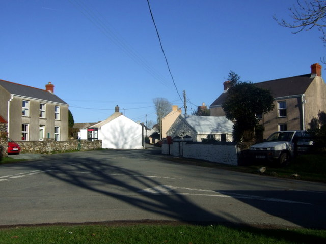
English: Treamlod/Ambleston village centre Tiny agricultural village (popn. 150) south of the Preselis.
From the community action plan 2005: "Despite Flemish settlements typical of Pembrokeshire roundabout Ambleston Parish, and despite more recent population changes, the character of Ambleston is decidedly Welsh. It would be wrong to include it in the dubious Little England beyond Wales description applied to South Pembrokeshire; mostly by travel brochures. The illdefined Landsker probably lies to the south of Ambleston although some historians have associated it with Woodstock. Most families rooted in the area are Welsh speaking and many use Welsh by choice." Ambleston has no pub, school or shops, although it used to have several. There is concern about the lack of amenities in the village and efforts are being made to restore community activities. |
| Date | |
| Source | From geograph.org.uk |
| Author | ceridwen |
| Attribution (required by the license) | ceridwen / Treamlod/Ambleston village centre / |
| Camera location | | View this and other nearby images on: OpenStreetMap |
|---|
Licensing

|
This image was taken from the Geograph project collection. See this photograph's page on the Geograph website for the photographer's contact details. The copyright on this image is owned by ceridwen and is licensed for reuse under the Creative Commons Attribution-ShareAlike 2.0 license.
|
- You are free:
- to share – to copy, distribute and transmit the work
- to remix – to adapt the work
- Under the following conditions:
- attribution – You must give appropriate credit, provide a link to the license, and indicate if changes were made. You may do so in any reasonable manner, but not in any way that suggests the licensor endorses you or your use.
- share alike – If you remix, transform, or build upon the material, you must distribute your contributions under the same or compatible license as the original.
File history
Click on a date/time to view the file as it appeared at that time.
| Date/Time | Thumbnail | Dimensions | User | Comment | |
|---|---|---|---|---|---|
| current | 19:21, 9 November 2009 | | 640 × 480 (54 KB) | Perry Rimmer | {{Information |Description={{en|1=h}} |Source=h |Author=h |Date=h |Permission= |other_versions= }} |
File usage
Global file usage
The following other wikis use this file: