
File:Amsterdam tram map 30 degrees.png
Size of this preview: 800 × 489 pixels. Other resolutions: 320 × 196 pixels | 640 × 391 pixels | 1,024 × 626 pixels | 1,280 × 782 pixels | 2,560 × 1,565 pixels | 5,401 × 3,301 pixels.
Original file (5,401 × 3,301 pixels, file size: 1.74 MB, MIME type: image/png)
| This is a file from the Wikimedia Commons. Information from its description page there is shown below. Commons is a freely licensed media file repository. You can help. |
Summary
| Description |
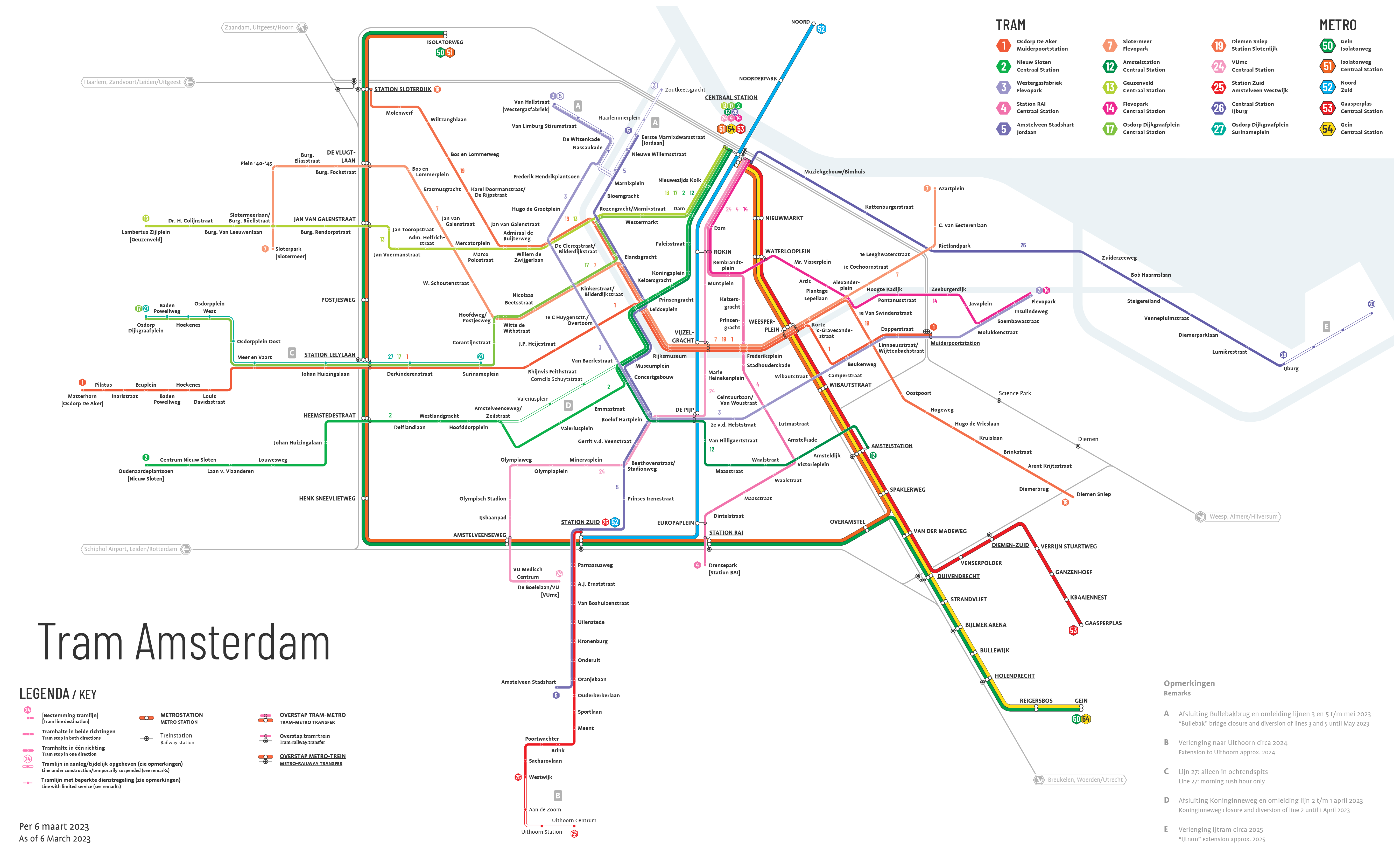
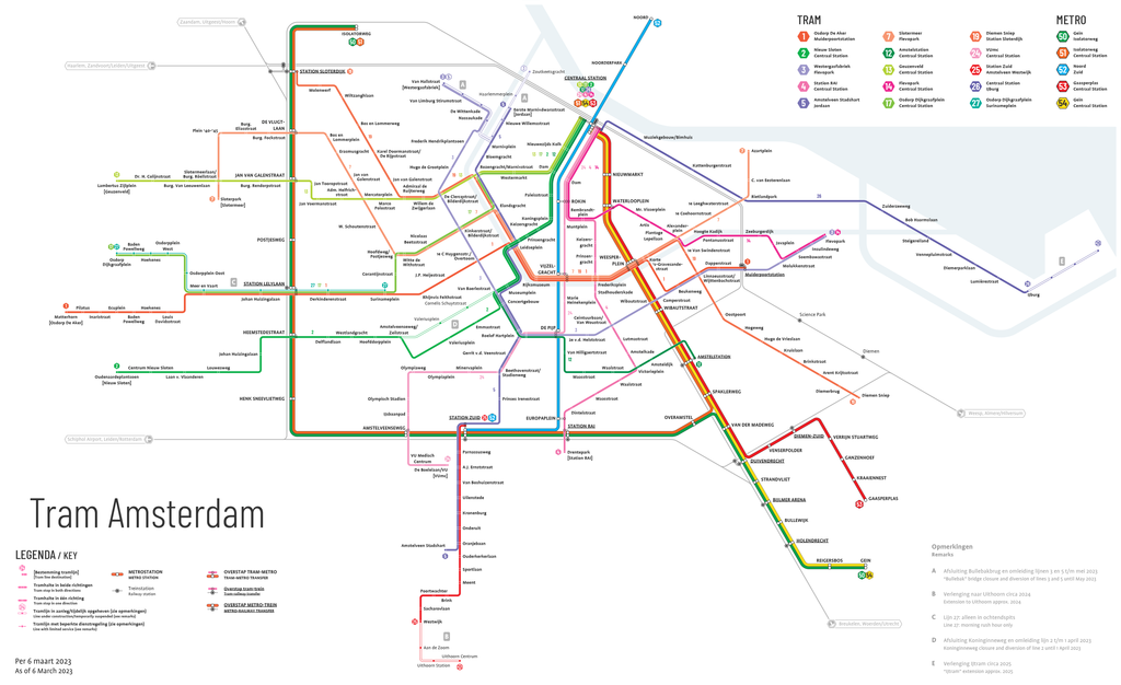
Nederlands: Diagram van het Amsterdamse tramnet met hoeken van 30 graden.
English: Amsterdam tram diagram with 30 degree angles. |
| Date | |
| Source | Own work |
| Author | Alargule |
Licensing
I, the copyright holder of this work, hereby publish it under the following license:
This file is licensed under the Creative Commons Attribution-Share Alike 4.0 International license.
- You are free:
- to share – to copy, distribute and transmit the work
- to remix – to adapt the work
- Under the following conditions:
- attribution – You must give appropriate credit, provide a link to the license, and indicate if changes were made. You may do so in any reasonable manner, but not in any way that suggests the licensor endorses you or your use.
- share alike – If you remix, transform, or build upon the material, you must distribute your contributions under the same or compatible license as the original.
File history
Click on a date/time to view the file as it appeared at that time.
| Date/Time | Thumbnail | Dimensions | User | Comment | |
|---|---|---|---|---|---|
| current | 13:44, 5 March 2023 | | 5,401 × 3,301 (1.74 MB) | Alargule | Return of lines 7 and 17 to their original routes; added Nicolaas Beetsstraat stop replacing Ten Katestraat and J.P. Heijestraat stops; added 2025 extension of line 26. |
| 10:36, 25 December 2022 |  | 5,001 × 3,251 (1.74 MB) | Alargule | Updated version as of 24 December | |
| 19:08, 29 May 2022 |  | 5,001 × 3,251 (1.74 MB) | Alargule | Diversions of lines 1, 2 and 17 added. | |
| 16:22, 12 December 2021 |  | 5,001 × 3,251 (1.66 MB) | Alargule | As per 12 december 2021. | |
| 14:22, 21 October 2021 |  | 5,001 × 3,251 (1.62 MB) | Alargule | Minor changes to layout | |
| 08:47, 3 October 2021 |  | 5,001 × 3,251 (1.62 MB) | Alargule | Merger of Cornelis Trooststraat and Scheldestraat stops into Van Hilligaertstraat stop (line 12) | |
| 14:42, 13 September 2021 |  | 5,001 × 3,251 (1.62 MB) | Alargule | Museumplein > Concertgebouw. Discontinuation of Rijksmuseum and Van Baerlastraat stops on 2-5-12 lines. New Museumplein stop on 2-5-12 lines. Layout changes. | |
| 06:26, 7 June 2021 |  | 5,001 × 3,251 (1.69 MB) | Alargule | Line 24 back to Centraal station, closure of Spui and Koningsplein stops, addition of new Koningsplein stop. | |
| 10:32, 5 January 2021 |  | 5,001 × 3,251 (1.72 MB) | Alargule | Opening of line 25; minor layout changes; three stops renamed (Osdorpplein > Osdorpplein West; Ruimzicht > Osdorpplein Oost; Kasterleepark > Centrum Nieuw Sloten). | |
| 10:23, 7 November 2020 |  | 5,001 × 3,251 (1.76 MB) | Alargule | Lijn 6 verwijderd. Removed line 6. |
File usage
The following pages on the English Wikipedia use this file (pages on other projects are not listed):
Global file usage
The following other wikis use this file:
- Usage on de.wikipedia.org
- Usage on fr.wikipedia.org
- Usage on id.wikipedia.org
- Usage on nl.wikipedia.org
- Usage on sv.wikipedia.org
- Usage on uk.wikipedia.org