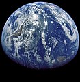
File:Apollo 15 Earth1.jpg

Size of this preview: 616 × 599 pixels. Other resolutions: 247 × 240 pixels | 493 × 480 pixels | 789 × 768 pixels | 1,053 × 1,024 pixels | 2,253 × 2,192 pixels.
Original file (2,253 × 2,192 pixels, file size: 1.08 MB, MIME type: image/jpeg)
File history
Click on a date/time to view the file as it appeared at that time.
| Date/Time | Thumbnail | Dimensions | User | Comment | |
|---|---|---|---|---|---|
| current | 11:00, 20 March 2015 |  | 2,253 × 2,192 (1.08 MB) | SteinsplitterBot | Bot: Image rotated by 270° |
| 09:28, 20 March 2015 |  | 2,199 × 2,253 (1.08 MB) | Jcpag2012 | Cropped 46 % horizontally and 45 % vertically using CropTool with lossless mode. | |
| 14:20, 20 December 2010 |  | 4,096 × 4,096 (1.35 MB) | Igorvyh | {{Information |Description={{en|1=The view of Earth taken during the Translunar Coast from the distance of about 25.000 to 30.000 nautical miles from Earth. South America is to the left. Central America is in the upper center. The gulf of Mexico and Flori |
File usage
The following pages on the English Wikipedia use this file (pages on other projects are not listed):
Global file usage
The following other wikis use this file:
- Usage on ar.wikipedia.org
- Usage on it.wikipedia.org
- Usage on ru.wikipedia.org
- Usage on uk.wikipedia.org
- Usage on zh.wikipedia.org


