
File:Baden Railwaymap 1870.png

Size of this preview: 429 × 599 pixels. Other resolutions: 172 × 240 pixels | 344 × 480 pixels | 550 × 768 pixels | 733 × 1,024 pixels | 1,364 × 1,904 pixels.
Original file (1,364 × 1,904 pixels, file size: 247 KB, MIME type: image/png)
| This is a file from the Wikimedia Commons. Information from its description page there is shown below. Commons is a freely licensed media file repository. You can help. |
Summary
| Description |
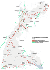
Map of the railway lines in Baden 1870 Deutsch: Plan der Eisenbahnstrecken in Baden 1870 |
| Date | 15 January 2006 (upload date) |
| Source | map created by MCMC |
| Author | MCMC |
| Permission (Reusing this file) |
MCMC puts it under CC-By-SA |
Licensing
This file is licensed under the Creative Commons Attribution 2.5 Generic license.
- You are free:
- to share – to copy, distribute and transmit the work
- to remix – to adapt the work
- Under the following conditions:
- attribution – You must give appropriate credit, provide a link to the license, and indicate if changes were made. You may do so in any reasonable manner, but not in any way that suggests the licensor endorses you or your use.
File history
Click on a date/time to view the file as it appeared at that time.
| Date/Time | Thumbnail | Dimensions | User | Comment | |
|---|---|---|---|---|---|
| current | 00:15, 15 January 2006 | | 1,364 × 1,904 (247 KB) | MCMC | {{Information| |Description = Map of the railway lines in Baden 1870 |Source = map created by MCMC |Date = created 15. Jan. 2006 |Author = Martin Lauer (User MCMC) |Permission = MCMC puts it under CC-By-SA |othe |
File usage
The following pages on the English Wikipedia use this file (pages on other projects are not listed):
Global file usage
The following other wikis use this file:
- Usage on als.wikipedia.org
- Usage on de.wikipedia.org
- Usage on fr.wikipedia.org
- Usage on ja.wikipedia.org
- Usage on www.wikidata.org