
File:Balboa Park station complex map, 2018.svg

Size of this PNG preview of this SVG file: 393 × 599 pixels. Other resolutions: 157 × 240 pixels | 315 × 480 pixels | 504 × 768 pixels | 672 × 1,024 pixels | 1,344 × 2,048 pixels | 2,100 × 3,200 pixels.
Original file (SVG file, nominally 2,100 × 3,200 pixels, file size: 123 KB)
| This is a file from the Wikimedia Commons. Information from its description page there is shown below. Commons is a freely licensed media file repository. You can help. |
Summary
| Description |
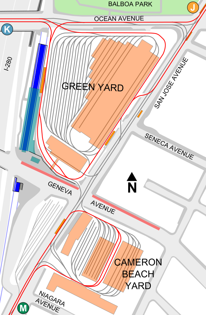
English: Map of the Balboa Park station complex, accurate to the 2018 completion of the Eastside Connector
Muni tracks used for revenue service
Muni tracks not used in revenue service
Muni platforms
Muni yard buildings
BART platform and tracks
BART station building |
| Date | |
| Source | Own work |
| Author | User:Pi.1415926535 |
Licensing
I, the copyright holder of this work, hereby publish it under the following licenses:

|
Permission is granted to copy, distribute and/or modify this document under the terms of the GNU Free Documentation License, Version 1.2 or any later version published by the Free Software Foundation; with no Invariant Sections, no Front-Cover Texts, and no Back-Cover Texts. A copy of the license is included in the section entitled GNU Free Documentation License. |
This file is licensed under the Creative Commons Attribution-Share Alike 4.0 International license.
- You are free:
- to share – to copy, distribute and transmit the work
- to remix – to adapt the work
- Under the following conditions:
- attribution – You must give appropriate credit, provide a link to the license, and indicate if changes were made. You may do so in any reasonable manner, but not in any way that suggests the licensor endorses you or your use.
- share alike – If you remix, transform, or build upon the material, you must distribute your contributions under the same or compatible license as the original.
You may select the license of your choice.
File history
Click on a date/time to view the file as it appeared at that time.
| Date/Time | Thumbnail | Dimensions | User | Comment | |
|---|---|---|---|---|---|
| current | 06:46, 12 March 2018 | | 2,100 × 3,200 (123 KB) | Pi.1415926535 | Add San Jose and Seneca mini-high; fade out unused Upper Yard |
| 06:26, 12 March 2018 |  | 2,100 × 3,200 (123 KB) | Pi.1415926535 | {{Information |description ={{en|1=Map of the Balboa Park station complex, accurate to the 2018 completion of the Eastside Connector}} |source ={{own}} |author =User:Pi.1415926535 |date =2018-03-12 }} Category:Balboa Park station complex Category:Muni Metro maps Category:BART maps Category:BART in 2018 Category:Maps by User:Pi.1415926535 |
File usage
The following pages on the English Wikipedia use this file (pages on other projects are not listed):