
File:Bearreraig Waterfall - geograph.org.uk - 947475.jpg
No higher resolution available.
Bearreraig_Waterfall_-_geograph.org.uk_-_947475.jpg (640 × 480 pixels, file size: 239 KB, MIME type: image/jpeg)
| This is a file from the Wikimedia Commons. Information from its description page there is shown below. Commons is a freely licensed media file repository. You can help. |
Summary
| Description |
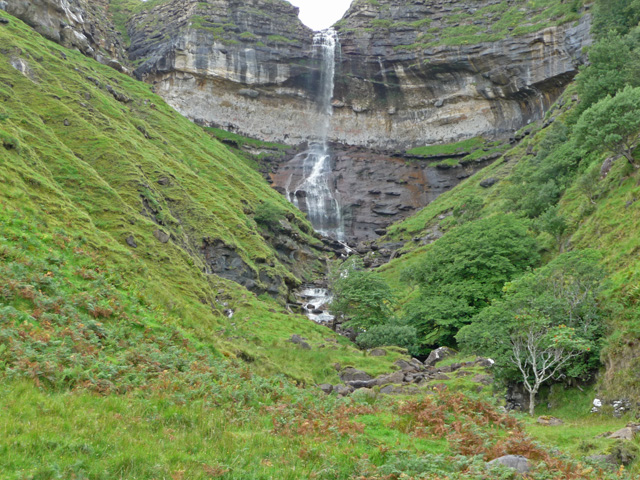
English: Bearreraig Waterfall, near to Bearreraig Bay [water Feature], Highland, Great Britain.
Most of the water that carved this gorge now reaches the sea via the power station <a href="https://www.geograph.org.uk/photo/88273">NG5152 : Storr Lochs Hydro Power Station</a>. This picture shows a more typical flow than <a href="https://www.geograph.org.uk/photo/107736">NG5152 : Loch Leathan falls.</a>. |
| Date | |
| Source | From geograph.org.uk; transferred by User:W. L. Tarbert using geograph_org2commons. |
| Author | John Allan |
| Permission (Reusing this file) |
Creative Commons Attribution Share-alike license 2.0 |
| Attribution (required by the license) | John Allan / Bearreraig Waterfall / |
| Camera location | | View this and other nearby images on: OpenStreetMap |
|---|
| Object location | | View this and other nearby images on: OpenStreetMap |
|---|
_region:GB-SCT_heading:225.00&language=en)
Licensing

|
This image was taken from the Geograph project collection. See this photograph's page on the Geograph website for the photographer's contact details. The copyright on this image is owned by John Allan and is licensed for reuse under the Creative Commons Attribution-ShareAlike 2.0 license.
|
This file is licensed under the Creative Commons Attribution-Share Alike 2.0 Generic license.
Attribution: John Allan
- You are free:
- to share – to copy, distribute and transmit the work
- to remix – to adapt the work
- Under the following conditions:
- attribution – You must give appropriate credit, provide a link to the license, and indicate if changes were made. You may do so in any reasonable manner, but not in any way that suggests the licensor endorses you or your use.
- share alike – If you remix, transform, or build upon the material, you must distribute your contributions under the same or compatible license as the original.
File history
Click on a date/time to view the file as it appeared at that time.
| Date/Time | Thumbnail | Dimensions | User | Comment | |
|---|---|---|---|---|---|
| current | 18:28, 17 September 2010 | | 640 × 480 (239 KB) | File Upload Bot (Magnus Manske) | == {{int:filedesc}} == {{Information |Description={{en|1=Bearreraig Waterfall, near to Bearreraig Bay [water Feature], Highland, Great Britain. Most of the water that carved this gorge now reaches the sea via the power station <a href="http://www.geograph |
File usage
The following pages on the English Wikipedia use this file (pages on other projects are not listed):
Global file usage
The following other wikis use this file: