
File:BeavertonTransitCenter SEside.jpg

Size of this preview: 800 × 536 pixels. Other resolutions: 320 × 214 pixels | 640 × 429 pixels | 1,024 × 686 pixels | 1,280 × 857 pixels | 2,999 × 2,008 pixels.
Original file (2,999 × 2,008 pixels, file size: 1.8 MB, MIME type: image/jpeg)
| This is a file from the Wikimedia Commons. Information from its description page there is shown below. Commons is a freely licensed media file repository. You can help. |
Summary
| Description |
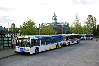
English: The southeast side of the bus loop at the Beaverton Transit Center of TriMet, the regional transit agency serving Portland, Oregon and surrounding areas. This transit center, located in central Beaverton, Oregon, opened in 1988 for buses, and later became served by light rail starting in 1998 and by commuter rail in 2009. The buses shown are two 2009-built New Flyer D40LFRs and a 1994-built Flxible Metro. At the time of the picture, the D40LFR was TriMet's newest type of bus and the Flxible Metro was a common sight. Subsequently, TriMet's last Flxible Metros were retired in 2015, and the D40LFR is now TriMet's oldest model of bus still in service. |
| Date | |
| Source | Own work |
| Author | Steve Morgan |
| Permission (Reusing this file) |
See below; include credit to the photographer on any reuse outside Wikipedia. |
| Camera location | | View this and other nearby images on: OpenStreetMap |
|---|
Licensing
I, the copyright holder of this work, hereby publish it under the following licenses:
This file is licensed under the Creative Commons Attribution-Share Alike 3.0 Unported license.
- You are free:
- to share – to copy, distribute and transmit the work
- to remix – to adapt the work
- Under the following conditions:
- attribution – You must give appropriate credit, provide a link to the license, and indicate if changes were made. You may do so in any reasonable manner, but not in any way that suggests the licensor endorses you or your use.
- share alike – If you remix, transform, or build upon the material, you must distribute your contributions under the same or compatible license as the original.

|
Permission is granted to copy, distribute and/or modify this document under the terms of the GNU Free Documentation License, Version 1.2 or any later version published by the Free Software Foundation; with no Invariant Sections, no Front-Cover Texts, and no Back-Cover Texts. A copy of the license is included in the section entitled GNU Free Documentation License. |
You may select the license of your choice.
File history
Click on a date/time to view the file as it appeared at that time.
| Date/Time | Thumbnail | Dimensions | User | Comment | |
|---|---|---|---|---|---|
| current | 11:38, 15 August 2009 | | 2,999 × 2,008 (1.8 MB) | Steve Morgan | {{Information |Description={{en|1=The southeast side of the bus loop at the Beaverton Transit Center of TriMet, the regional transit agency serving Portland, Oregon and surrounding areas. |
File usage
The following pages on the English Wikipedia use this file (pages on other projects are not listed):
Global file usage
The following other wikis use this file:
- Usage on en.wikivoyage.org