
File:BlueLine ver2.jpg

Size of this preview: 800 × 553 pixels. Other resolutions: 320 × 221 pixels | 640 × 442 pixels | 1,024 × 708 pixels | 1,299 × 898 pixels.
Original file (1,299 × 898 pixels, file size: 238 KB, MIME type: image/jpeg)
| This is a file from the Wikimedia Commons. Information from its description page there is shown below. Commons is a freely licensed media file repository. You can help. |

|
This military map image could be re-created using vector graphics as an SVG file. This has several advantages; see Commons:Media for cleanup for more information. If an SVG form of this image is available, please upload it and afterwards replace this template with
{{vector version available|new image name}}.
It is recommended to name the SVG file “BlueLine ver2.svg”—then the template Vector version available (or Vva) does not need the new image name parameter. |


Summary
| Description |
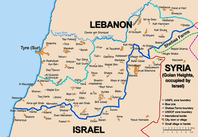
English: Map showing the Blue Line demarcation line between Lebanon and Israel, established by the UN after the Israeli withdrawal from southern Lebanon after its short 1978 invasion called "Operation Litani". It follows the 1949 cease-fire line, also known as the Green Line, as well as the somewhat contested Lebanese-Syrian border towards the Israeli-occupied Golan Heights. The map is made by Thomas Blomberg, using the UNIFIL map, deployment as of July 2006 as source.
Español: Sumario. Mapa mostrando a la línea de demarcación de Línea Azul entre Líbano y Israel, establecido por las Naciones Unidas después de la retirada israelí de Líbano del sur después de su invasión de 1978 corta llamada " Operación Litani ". Esto sigue la línea de alto el fuego 1949, también sabida(conocida) como la Línea Verde, así como la frontera algo impugnada libanesa siria hacia Altos del Golán Ocupados por israelí. El mapa es hecho por Thomas Blomberg, usando el mapa de UNIFIL, el despliegue desde el julio de 2006 como la fuente |
| Date | |
| Source |
|
| Author | Thomas Blomberg |
| Other versions |
|

Licensing
Thomas Blomberg, the copyright holder of this work, hereby publishes it under the following license:
This file is licensed under the Creative Commons Attribution-Share Alike 2.5 Generic license.
Attribution: Thomas Blomberg
- You are free:
- to share – to copy, distribute and transmit the work
- to remix – to adapt the work
- Under the following conditions:
- attribution – You must give appropriate credit, provide a link to the license, and indicate if changes were made. You may do so in any reasonable manner, but not in any way that suggests the licensor endorses you or your use.
- share alike – If you remix, transform, or build upon the material, you must distribute your contributions under the same or compatible license as the original.
File history
Click on a date/time to view the file as it appeared at that time.
| Date/Time | Thumbnail | Dimensions | User | Comment | |
|---|---|---|---|---|---|
| current | 01:35, 16 February 2010 | | 1,299 × 898 (238 KB) | Jarekt | == {{int:filedesc}} == {{Information |Description= {{en|Map showing the Blue Line demarcation line between Lebanon and Israel, established by the UN after the Israeli withdrawal from southern Lebanon |
File usage
The following pages on the English Wikipedia use this file (pages on other projects are not listed):
Global file usage
The following other wikis use this file:
- Usage on ar.wikipedia.org
- Usage on bn.wikipedia.org
- Usage on ca.wikipedia.org
- Usage on ckb.wikipedia.org
- Usage on fa.wikipedia.org
- Usage on fr.wikipedia.org
- Usage on mzn.wikipedia.org
- Usage on nl.wikipedia.org
- Usage on www.wikidata.org