
File:Bolsover South railway station.jpg
Bolsover_South_railway_station.jpg (640 × 357 pixels, file size: 87 KB, MIME type: image/jpeg)
| This is a file from the Wikimedia Commons. Information from its description page there is shown below. Commons is a freely licensed media file repository. You can help. |
Summary
| Description |
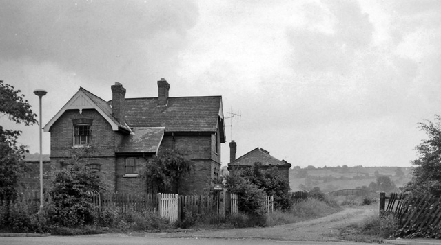
English: Bolsover South Station (converted).
View eastwards, towards Langwith Junction and Lincoln; ex-GC(LD&EC) Lincoln - Tuxford - Langwith - Chesterfield Market Place line. Station closed 3/12/51. The line from Markham Junction through Bolsover South, Bolsover Tunnel and Scarcliffe to the road bridge 300 yards east of Shirebrook North was lifted within three weeks because of the state of Bolsover Tunnel and Carr Vale Viaduct. Chesterfield Market Place and Arkwright Town stations remained open to goods traffic until 4/3/57 whereafter the stretch from Chesterfield MP to Deepsick Lane, Arkwright was lifted. Date of Markham Junction to Longcourse Lane, Duckmanton closure not known. Longcourse Lane to Deepsick Lane remained open for many years to serve Arkwright Colliery via Duckmanton North and East Junctions. Eventually this was rationalised by relaying track from Duckmanton North Junction south along the GC main line trackbed to a new connection straight into Arkwright Colliery, which promptly gave notice of closure! The photo shows the Bolsover South Station Master's house as a private dwelling in 1963. The station building itself was behind the bush on the extreme right of the photo. The architecture of the building shown is very much of a family with "Railway Cottages" on the main A632 half way between the bottom of Bolsover Hill and Markham Lane End, with the house immediately next to Clowne South station site (near Wilkinsons in the middle of Clowne) and with several buildings in Langwith Junction and Scarcliffe, some of which were never railway property but were built at the same time as the LDECR in the late 1890s. I'm sure there are others remaining along the route. |
| Date | Taken on 13 July 1963 |
| Source | From geograph.org.uk |
| Author | Ben Brooksbank |
| Permission (Reusing this file) |
Creative Commons Attribution Share-alike license 2.0 |
| Camera location | | View this and other nearby images on: OpenStreetMap |
|---|
Licensing

|
This image was taken from the Geograph project collection. See this photograph's page on the Geograph website for the photographer's contact details. The copyright on this image is owned by Ben Brooksbank and is licensed for reuse under the Creative Commons Attribution-ShareAlike 2.0 license.
|
- You are free:
- to share – to copy, distribute and transmit the work
- to remix – to adapt the work
- Under the following conditions:
- attribution – You must give appropriate credit, provide a link to the license, and indicate if changes were made. You may do so in any reasonable manner, but not in any way that suggests the licensor endorses you or your use.
- share alike – If you remix, transform, or build upon the material, you must distribute your contributions under the same or compatible license as the original.
File history
Click on a date/time to view the file as it appeared at that time.
| Date/Time | Thumbnail | Dimensions | User | Comment | |
|---|---|---|---|---|---|
| current | 14:58, 10 May 2010 | | 640 × 357 (87 KB) | Chevin | == {{int:filedesc}} == {{Information |Description={{en|1=Bolsover South Station (converted)}} View eastwards, towards Langwith Junction and Lincoln; ex-GC(LD&EC) Lincoln - Tuxford - Langwith - Chesterfield Market Place line. Station closed 3/12/51 and lin |
File usage
Global file usage
The following other wikis use this file:
- Usage on www.wikidata.org