
File:Boscombe, Opera House and Royal Arcade - geograph.org.uk - 882007.jpg
No higher resolution available.
Boscombe,_Opera_House_and_Royal_Arcade_-_geograph.org.uk_-_882007.jpg (640 × 480 pixels, file size: 77 KB, MIME type: image/jpeg)
| This is a file from the Wikimedia Commons. Information from its description page there is shown below. Commons is a freely licensed media file repository. You can help. |
Summary
| Description |
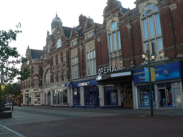
English: Boscombe: Opera House and Royal Arcade Looking along the 881985, we see firstly the Opera House, which is above the shops and was indeed an opera house originally. More recently it became a nightclub and is now a nighttime music venue.
Farther down, we see Boscombe Precinct Post Office. The post office, called simple Boscombe, was on the other side of the road but moved on 29 March 1993 into Safeway supermarket in the newly opened 881990. A few years on and this branch opened; the two coexisted for a short while before the one inside Safeway closed. Between the two is the entrance to the Royal Arcade, which very much resembles its other entrance around the corner in Palmerston Road (see 881970). |
| Date | |
| Source | From geograph.org.uk |
| Author | Chris Downer |
| Attribution (required by the license) | Chris Downer / Boscombe: Opera House and Royal Arcade / |
| Camera location | | View this and other nearby images on: OpenStreetMap |
|---|
_heading:292.00&language=en)
| Object location | | View this and other nearby images on: OpenStreetMap |
|---|
_heading:292.00&language=en)
Licensing

|
This image was taken from the Geograph project collection. See this photograph's page on the Geograph website for the photographer's contact details. The copyright on this image is owned by Chris Downer and is licensed for reuse under the Creative Commons Attribution-ShareAlike 2.0 license.
|
This file is licensed under the Creative Commons Attribution-Share Alike 2.0 Generic license.
Attribution: Chris Downer
- You are free:
- to share – to copy, distribute and transmit the work
- to remix – to adapt the work
- Under the following conditions:
- attribution – You must give appropriate credit, provide a link to the license, and indicate if changes were made. You may do so in any reasonable manner, but not in any way that suggests the licensor endorses you or your use.
- share alike – If you remix, transform, or build upon the material, you must distribute your contributions under the same or compatible license as the original.
File history
Click on a date/time to view the file as it appeared at that time.
| Date/Time | Thumbnail | Dimensions | User | Comment | |
|---|---|---|---|---|---|
| current | 11:51, 21 February 2011 | | 640 × 480 (77 KB) | GeographBot | == {{int:filedesc}} == {{Information |description={{en|1=Boscombe: Opera House and Royal Arcade Looking along the 881985, we see firstly the Opera House, which is above the shops and was indeed an opera house originally. More recently it became a nigh |
File usage
The following pages on the English Wikipedia use this file (pages on other projects are not listed):
Global file usage
The following other wikis use this file:
- Usage on www.wikidata.org