
File:Bridge(mcalister-crossing)(mueller-bridge)2016-3.jpg

Size of this preview: 800 × 533 pixels. Other resolutions: 320 × 213 pixels | 640 × 427 pixels | 1,024 × 683 pixels | 1,280 × 853 pixels | 1,659 × 1,106 pixels.
Original file (1,659 × 1,106 pixels, file size: 1.28 MB, MIME type: image/jpeg)
| This is a file from the Wikimedia Commons. Information from its description page there is shown below. Commons is a freely licensed media file repository. You can help. |
(mueller-bridge)2016-3.jpg)
Summary
| Description |
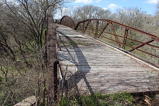
English: Bridge at McAlister Crossing (Mueller Bridge) (2/10 mi. SW). John Murphy McAlister (1807-1885) and his wife, Isabella (McClain) (1817-1872), settled in La Vernia with their family in the early 1850s. In 1857, they purchased several hundred acres of land on the southwest bank of Cibolo Creek. The natural stream crossing adjacent to their property became known as McAlister Crossing and for years served residents on both sides. The McAlister children subdivided the land following their father's death in 1885. About the same time, county commissioners designated the local route, including the crossing, as Road No. 62 (present County Road 337). In 1906, the Henry Mueller family purchased land on the east side of the creek; a son would later buy land on the west side, just southwest of McAlister Crossing. In 1908, county commissioners permitted the placement of telephone poles along the road and the creek crossing. In 1915, the Commissioners Court contracted with the Alamo Construction Company of San Antonio to erect five bridges in the county, including one at McAlister Crossing. The most expensive of the new structures, the bridge at McAlister Crossing, completed in 1915, cost nearly $9,000. Because members of the Mueller family owned property on either end of the bridge, it was often called Mueller Bridge. The three-span, 252-foot Mueller Bridge at McAlister Crossing features polygonal camelback trusses with multiple panels. For more than 70 years it served local residents, surviving Cibolo Creek's occasional raging waters. Closed to vehicular traffic in 1988, it remains a historic link to engineering designes of the early 20th century. Recorded Texas Historic Landmark - 2004 #13258
|
||
| Date | |||
| Source | Own work | ||
| Author | Darrylpearson |
FM 539 & CR 337, La Vernia, TX, United States
Licensing
I, the copyright holder of this work, hereby publish it under the following license:
This file is licensed under the Creative Commons Attribution-Share Alike 4.0 International license.
- You are free:
- to share – to copy, distribute and transmit the work
- to remix – to adapt the work
- Under the following conditions:
- attribution – You must give appropriate credit, provide a link to the license, and indicate if changes were made. You may do so in any reasonable manner, but not in any way that suggests the licensor endorses you or your use.
- share alike – If you remix, transform, or build upon the material, you must distribute your contributions under the same or compatible license as the original.
File history
Click on a date/time to view the file as it appeared at that time.
| Date/Time | Thumbnail | Dimensions | User | Comment | |
|---|---|---|---|---|---|
| current | 04:23, 28 January 2017 | | 1,659 × 1,106 (1.28 MB) | Darrylpearson | User created page with UploadWizard |
File usage
The following pages on the English Wikipedia use this file (pages on other projects are not listed):
Global file usage
The following other wikis use this file:
- Usage on de.wikipedia.org
- Usage on www.wikidata.org
(mueller-bridge)2016-3.jpg)