
File:Cape of Good Hope Iss059e078303 lrg, Diep River.jpg

Size of this preview: 526 × 600 pixels. Other resolutions: 210 × 240 pixels | 421 × 480 pixels | 674 × 768 pixels | 898 × 1,024 pixels | 1,608 × 1,833 pixels.
Original file (1,608 × 1,833 pixels, file size: 796 KB, MIME type: image/jpeg)
| This is a file from the Wikimedia Commons. Information from its description page there is shown below. Commons is a freely licensed media file repository. You can help. |
Summary
| Description |
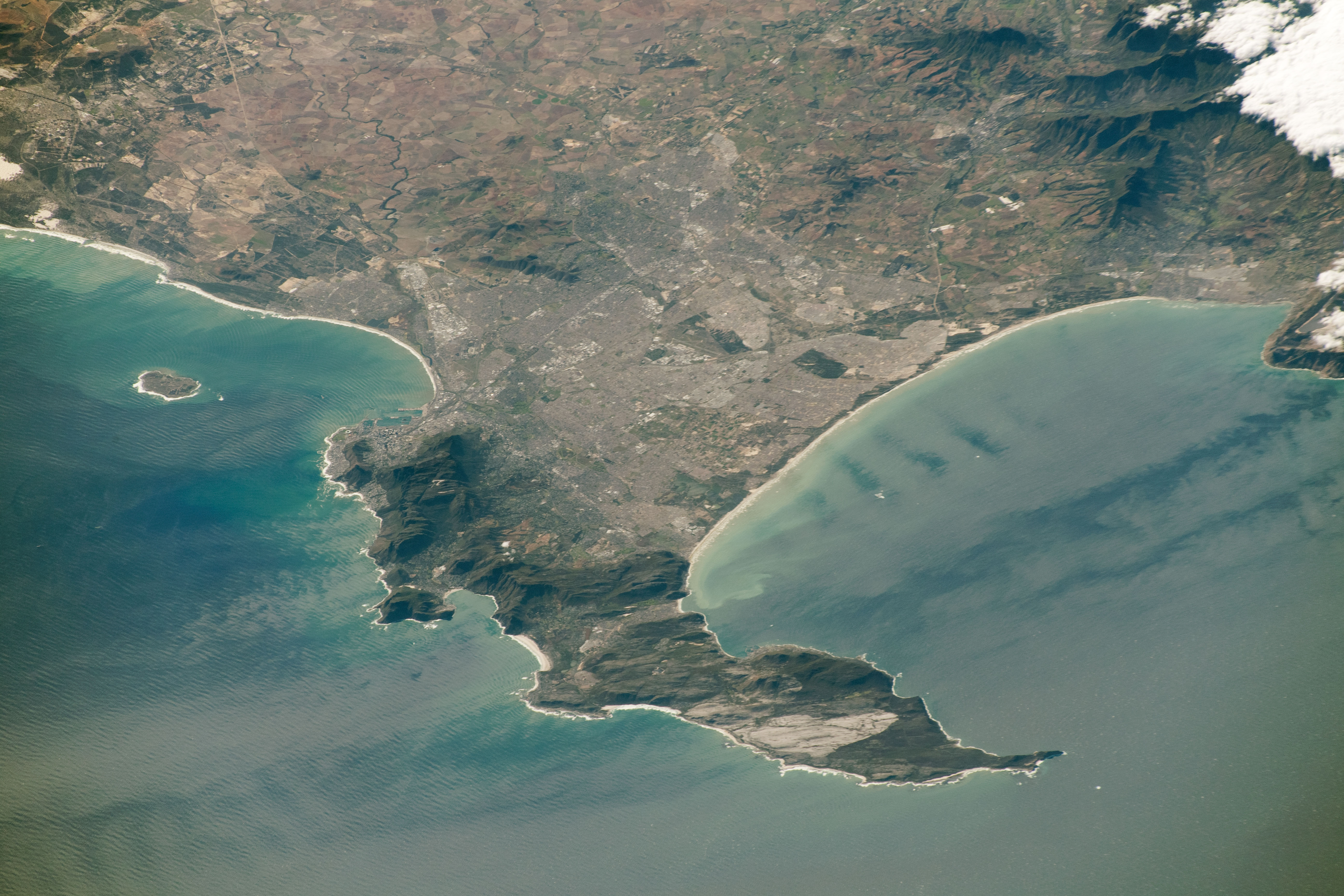
Afrikaans: Die loop van die Dieprivier is duidelik tussen koringlande van die Swartland in die Wes-Kaap, Suid-Afrika, sigbaar. Weerskante van die rivier vorm die N7-roete op linkerhand en Ou Malmesburypad, regs, reguit lyne. Kalbaskraal se spilpuntbesproeiing is aan die bokant van die beeld sigbaar, en Malmesbury is net buite sig. Net bo die beeldmidde, te Goedontmoeting-plaas naby Philadelphia, het die gekromde Mosselbankrivier 'n sameloop met die Dieprivier.
Ruimtevaarderfoto ISS059-E-78303 is op 28 Mei 2019 deur middel van 'n Nikon D5 digitale kamera met 340 millimeter lens verkry, en is deur die IRS-bemanning se Aardwaarnemingsgerief en die Aardwetenskap-en-Afstandwaarnemingseenheid van die Johnson-ruimtesentrum voorsien. Die foto is deur 'n lid van die Ekspedisie 59-span geneem. English: The course of the Diep River is clearly visible among wheat fields of the Swartland, Western Cape, South Africa. The N7 route and Old Malmesbury Road respectively form straight lines on the left and right sides of the river. The curved course of the Mosselbank River, a left bank tributary of the Diep, is also visible. Astronaut photograph ISS059-E-78303 was acquired on May 28, 2019, with a Nikon D5 digital camera using a 340 millimeter lens and is provided by the ISS Crew Earth Observations Facility and the Earth Science and Remote Sensing Unit, Johnson Space Center. The image was taken by a member of the Expedition 59 crew. |
| Date | |
| Source | https://eoimages.gsfc.nasa.gov/images/imagerecords/145000/145476/iss059e078303_lrg.jpg |
| Author |
Afrikaans: Die Internasionale Ruimtestasieprogram ondersteun die laboratorium as deel van die IRS Nasionale Laboratorium om ruimtevaarders te help om foto's van die Aarde te neem wat die grootste waarde vir wetenskaplikes en die publiek sal hê, en om hierdie beelde vrylik op die internet beskikbaar te stel. Bykomende beelde wat deur ruimtevaarders en kosmonoute geneem is, kan besigtig word by die NASA/JSC Gateway to Astronaut Photography of Earth. Onderskrif deur Sarah Deitrick, 'n Jacobs-JETS-gekontrakteerde by NASA-JSC.
English: The International Space Station Program supports the laboratory as part of the ISS National Lab to help astronauts take pictures of Earth that will be of the greatest value to scientists and the public, and to make those images freely available on the Internet. Additional images taken by astronauts and cosmonauts can be viewed at the NASA/JSC Gateway to Astronaut Photography of Earth. Caption by Sarah Deitrick, Jacobs-JETS Contract at NASA-JSC. |
| Other versions |
 |
| Object location | | View this and other nearby images on: OpenStreetMap |
|---|
Licensing
| This file is in the public domain in the United States because it was solely created by NASA. NASA copyright policy states that "NASA material is not protected by copyright unless noted". (See Template:PD-USGov, NASA copyright policy page or JPL Image Use Policy.) | ||
 |
Warnings:
|
File history
Click on a date/time to view the file as it appeared at that time.
| Date/Time | Thumbnail | Dimensions | User | Comment | |
|---|---|---|---|---|---|
| current | 12:41, 9 July 2020 | | 1,608 × 1,833 (796 KB) | JMK | {{Information |description ={{en|1=Course of the Diep River visible among wheat fields of the Swartland, Western Cape, South Africa}} |date =2019-05-28 |source =https://eoimages.gsfc.nasa.gov/images/imagerecords/145000/145476/iss059e078303_lrg.jpg |author =NASA }} Category:Diep River |
File usage
The following pages on the English Wikipedia use this file (pages on other projects are not listed):
Global file usage
The following other wikis use this file:
- Usage on af.wikipedia.org
- Usage on ceb.wikipedia.org
- Usage on de.wikipedia.org