
File:Carlton Tavern - geograph.org.uk - 483947.jpg
No higher resolution available.
Carlton_Tavern_-_geograph.org.uk_-_483947.jpg (640 × 480 pixels, file size: 92 KB, MIME type: image/jpeg)
| This is a file from the Wikimedia Commons. Information from its description page there is shown below. Commons is a freely licensed media file repository. You can help. |
| This image appeared on Wikipedia's Main Page in the Did you know? column on 4 June 2015 (see archives). |
Summary
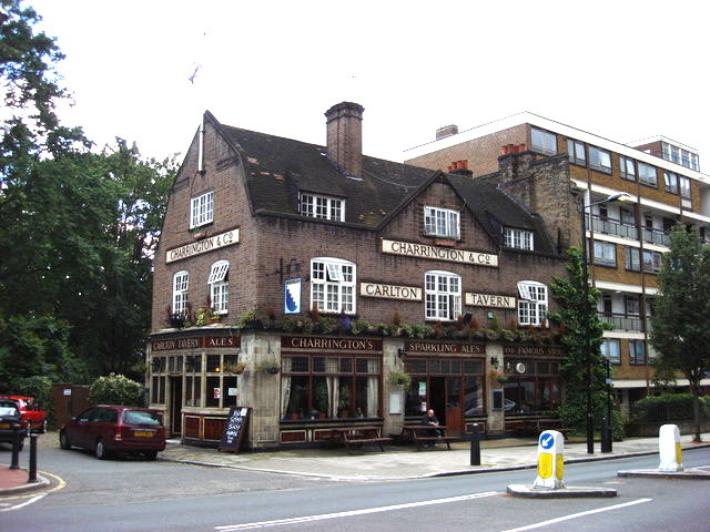
| Description |
English: The Carlton Tavern pub, Carlton Vale, built 1920-21 for the Charrington Brewery. The building was being considered by Historic England for Grade II listing when it was unexpectedly demolished in March 2015 by the property developer CLTX Ltd to make way for a new block of flats. "Bulldozers level historic pub after being denied planning permission". The Telegraph. Archived from the original on 16 April 2015. Retrieved on 17 April 2015. |
| Date | |
| Source | From geograph.org.uk |
| Author | Oxyman |
| Attribution (required by the license) | Oxyman / Carlton Tavern / |
| Camera location | | View this and other nearby images on: OpenStreetMap |
|---|
_heading:202.00&language=en)
| Object location | | View this and other nearby images on: OpenStreetMap |
|---|
_heading:202.00&language=en)
Licensing

|
This image was taken from the Geograph project collection. See this photograph's page on the Geograph website for the photographer's contact details. The copyright on this image is owned by Oxyman and is licensed for reuse under the Creative Commons Attribution-ShareAlike 2.0 license.
|
This file is licensed under the Creative Commons Attribution-Share Alike 2.0 Generic license.
Attribution: Oxyman
- You are free:
- to share – to copy, distribute and transmit the work
- to remix – to adapt the work
- Under the following conditions:
- attribution – You must give appropriate credit, provide a link to the license, and indicate if changes were made. You may do so in any reasonable manner, but not in any way that suggests the licensor endorses you or your use.
- share alike – If you remix, transform, or build upon the material, you must distribute your contributions under the same or compatible license as the original.
File history
Click on a date/time to view the file as it appeared at that time.
| Date/Time | Thumbnail | Dimensions | User | Comment | |
|---|---|---|---|---|---|
| current | 22:12, 9 May 2015 | | 640 × 480 (92 KB) | Philafrenzy | adjust levels |
| 01:09, 5 February 2011 |  | 640 × 480 (92 KB) | GeographBot | == {{int:filedesc}} == {{Information |description={{en|1=Carlton Tavern The road in the foreground is Carlton Vale}} |date=2007-06-29 |source=From [http://www.geograph.org.uk/photo/483947 geograph.org.uk] |author=[http://www.geograph.org.uk/profile/13090 |
File usage
The following pages on the English Wikipedia use this file (pages on other projects are not listed):
Global file usage
The following other wikis use this file:
- Usage on azb.wikipedia.org
- Usage on de.wikipedia.org