
File:Carte de l'Ile de France.svg

Size of this PNG preview of this SVG file: 647 × 600 pixels. Other resolutions: 259 × 240 pixels | 518 × 480 pixels | 828 × 768 pixels | 1,104 × 1,024 pixels | 2,209 × 2,048 pixels | 2,627 × 2,436 pixels.
Original file (SVG file, nominally 2,627 × 2,436 pixels, file size: 1.48 MB)
| This is a file from the Wikimedia Commons. Information from its description page there is shown below. Commons is a freely licensed media file repository. You can help. |
Summary
| Description |
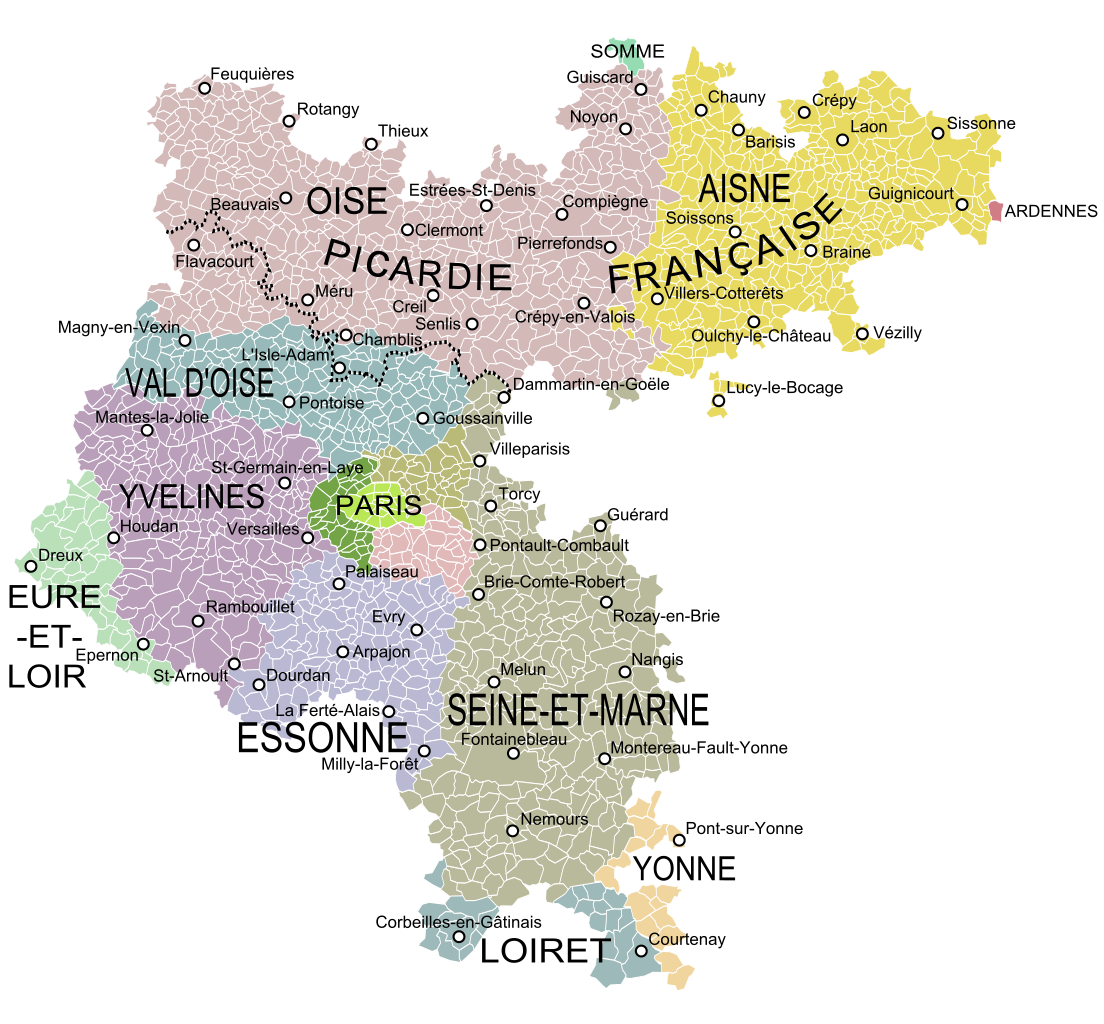
English: Map of the old military government of Ile de France, France, showing the communes according to the current administrative division. Français : Carte de l'ancien gouvernement militaire de l'Ile de France montrant les communes et les départements actuels. |
| Date | |
| Source |
|
| Author | Oie blanche, Vaulxnoy |
Licensing
I, the copyright holder of this work, hereby publish it under the following license:
This file is licensed under the Creative Commons Attribution-Share Alike 3.0 Unported license.
- You are free:
- to share – to copy, distribute and transmit the work
- to remix – to adapt the work
- Under the following conditions:
- attribution – You must give appropriate credit, provide a link to the license, and indicate if changes were made. You may do so in any reasonable manner, but not in any way that suggests the licensor endorses you or your use.
- share alike – If you remix, transform, or build upon the material, you must distribute your contributions under the same or compatible license as the original.
File history
Click on a date/time to view the file as it appeared at that time.
| Date/Time | Thumbnail | Dimensions | User | Comment | |
|---|---|---|---|---|---|
| current | 08:46, 28 April 2024 | | 2,627 × 2,436 (1.48 MB) | Vaulxnoy | Reverted to version as of 17:24, 27 April 2024 (UTC) L'expression Picardie française est utilisée par certains cartographes pour désigner la partie du Gouvernement militaire de l'IDF ne se confondant pas dans la province. C'est une nuance qu'il est raisonnable de préciser ici. Retour à la version précédente. |
| 07:14, 28 April 2024 |  | 2,627 × 2,436 (1.48 MB) | Francili | Reverted to version as of 03:50, 12 May 2013 (UTC) L’utilisation des termes « Picardie française » sur une carte de Sanson datée de 1722 est discutable puisqu’à cette date Beauvaisis, Noyonnais, Soissonnais, Laonnois, … rattachés un temps à la ceinture défensive constituée du Calaisis à la Thiérache autour des Flandres et de l'Artois espagnols, ou gouvernement militaire dit de Picardie, sont retournés à l’île de France, lorsque le royaume de France contrôle de nouveau l'Artois fin 1641. Les l... | |
| 17:24, 27 April 2024 |  | 2,627 × 2,436 (1.48 MB) | Vaulxnoy | Reverted to version as of 18:47, 19 January 2024 (UTC) | |
| 16:57, 27 April 2024 |  | 2,627 × 2,436 (1.48 MB) | Francili | Reverted to version as of 14:29, 19 January 2024 (UTC) | |
| 18:47, 19 January 2024 |  | 2,627 × 2,436 (1.48 MB) | Vaulxnoy | L'expression Picardie française est historiquement employée pour qualifier cette zone, et est présente sur la carte de Sanson indiquée en description, que vous auriez consultée si vous faisiez les choses attentivement, je vous mets le lien ici afin que vous n'ayez plus d'excuse : https://gallica.bnf.fr/ark:/12148/btv1b8444388s/f1.item.zoom | |
| 14:29, 19 January 2024 |  | 2,627 × 2,436 (1.48 MB) | CampagnardDeter | La "Picardie française" est un concept, tout du moins une expression, totalement inventée Reverted to version as of 20:15, 17 January 2024 (UTC) | |
| 02:04, 19 January 2024 |  | 2,627 × 2,436 (1.48 MB) | Vaulxnoy | Reverted to version as of 17:10, 11 July 2023 (UTC) | |
| 20:15, 17 January 2024 |  | 2,627 × 2,436 (1.48 MB) | CampagnardDeter | Reverted to version as of 03:50, 12 May 2013 (UTC) | |
| 17:10, 11 July 2023 |  | 2,627 × 2,436 (1.48 MB) | Vaulxnoy | Rajout d'informations sur le nord du gouvernement. | |
| 03:50, 12 May 2013 |  | 2,627 × 2,436 (1.48 MB) | Oie blanche | User created page with UploadWizard |
File usage
The following pages on the English Wikipedia use this file (pages on other projects are not listed):
Global file usage
The following other wikis use this file:
- Usage on br.wikipedia.org
- Usage on de.wikipedia.org
- Usage on el.wikipedia.org
- Usage on es.wikipedia.org
- Usage on fr.wikipedia.org
- Usage on fr.wiktionary.org
- Usage on it.wikipedia.org
- Usage on ja.wikipedia.org
- Usage on ko.wikipedia.org
- Usage on vls.wikipedia.org
- Usage on zh.wikipedia.org