
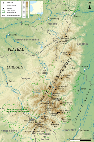
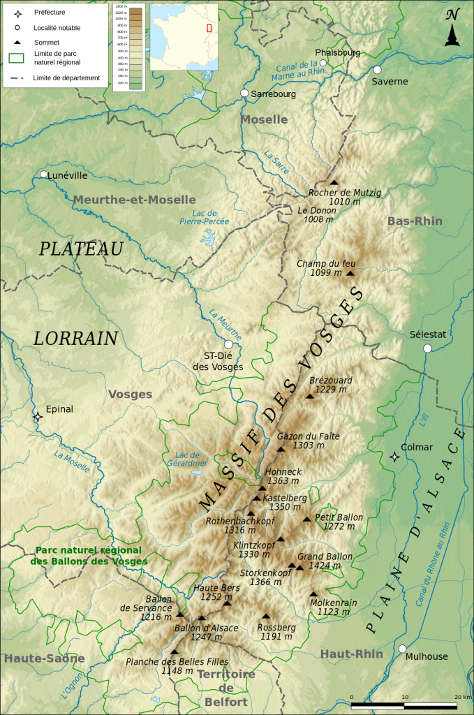
File:Carte topographique des Vosges.svg

Size of this PNG preview of this SVG file: 398 × 600 pixels. Other resolutions: 159 × 240 pixels | 318 × 480 pixels | 509 × 768 pixels | 679 × 1,024 pixels | 1,358 × 2,048 pixels | 1,271 × 1,916 pixels.
Original file (SVG file, nominally 1,271 × 1,916 pixels, file size: 4.01 MB)
| This is a file from the Wikimedia Commons. Information from its description page there is shown below. Commons is a freely licensed media file repository. You can help. |
Summary
| Description |
Français : Carte topographique des Vosges |
| Date | |
| Source |
Own work Relief : SRTM3 v2 Limites départementales : IGN-GEOFLA®
Minicarte : Blank map of Europe par Historicair Projection : Lambert 93 |
| Author | Boldair |
| Other versions |
|

Licensing
I, the copyright holder of this work, hereby publish it under the following license:
This file is licensed under the Creative Commons Attribution-Share Alike 4.0 International license.
- You are free:
- to share – to copy, distribute and transmit the work
- to remix – to adapt the work
- Under the following conditions:
- attribution – You must give appropriate credit, provide a link to the license, and indicate if changes were made. You may do so in any reasonable manner, but not in any way that suggests the licensor endorses you or your use.
- share alike – If you remix, transform, or build upon the material, you must distribute your contributions under the same or compatible license as the original.
File history
Click on a date/time to view the file as it appeared at that time.
| Date/Time | Thumbnail | Dimensions | User | Comment | |
|---|---|---|---|---|---|
| current | 11:43, 11 January 2016 | | 1,271 × 1,916 (4.01 MB) | Niko67000 | ajout de Sarrebourg, Phalsbourg et du Donon. |
| 08:36, 14 January 2015 |  | 1,271 × 1,916 (5.99 MB) | Boldair | meilleur relief | |
| 08:34, 14 January 2015 |  | 1,271 × 1,916 (5.99 MB) | Boldair | meilleur relief | |
| 21:05, 8 January 2015 |  | 1,271 × 1,916 (5.2 MB) | Boldair | allegement fichier | |
| 14:33, 8 January 2015 |  | 1,271 × 1,916 (6.11 MB) | Boldair | legende | |
| 14:04, 8 January 2015 |  | 1,271 × 1,916 (6.11 MB) | Boldair | Relief plus vert pour mieux faire apparaître les contours du massif | |
| 20:20, 7 January 2015 |  | 1,271 × 1,916 (5.44 MB) | Boldair | + un sommet | |
| 10:23, 7 January 2015 |  | 1,271 × 1,916 (5.44 MB) | Boldair | rectif | |
| 09:12, 7 January 2015 |  | 1,271 × 1,916 (5.44 MB) | Boldair | ajout minicarte | |
| 09:07, 7 January 2015 |  | 1,271 × 1,916 (5.42 MB) | Boldair | Rectif légende |
File usage
The following pages on the English Wikipedia use this file (pages on other projects are not listed):
Global file usage
The following other wikis use this file:
- Usage on af.wikipedia.org
- Usage on als.wikipedia.org
- Usage on an.wikipedia.org
- Usage on be.wikipedia.org
- Usage on cs.wikipedia.org
- Usage on de.wikipedia.org
- Usage on el.wikipedia.org
- Usage on eo.wikipedia.org
- Usage on es.wikipedia.org
- Usage on fa.wikipedia.org
- Usage on fi.wikipedia.org
- Usage on fr.wikipedia.org
- Usage on he.wikipedia.org
- Usage on hu.wikipedia.org
- Usage on id.wikipedia.org
- Usage on it.wikipedia.org
- Usage on ja.wikipedia.org
- Usage on ko.wikipedia.org
- Usage on nl.wikipedia.org
- Usage on pl.wikipedia.org
- Usage on pl.wikivoyage.org
- Usage on ro.wikipedia.org
- Usage on sh.wikipedia.org
- Usage on sk.wikipedia.org
- Usage on th.wikipedia.org
- Usage on uk.wikipedia.org
- Usage on zh.wikipedia.org