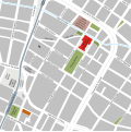
File:Catedral en el Centro- Medellin.svg

Size of this PNG preview of this SVG file: 599 × 599 pixels. Other resolutions: 240 × 240 pixels | 480 × 480 pixels | 768 × 768 pixels | 1,024 × 1,024 pixels | 2,047 × 2,048 pixels | 2,470 × 2,471 pixels.
Original file (SVG file, nominally 2,470 × 2,471 pixels, file size: 471 KB)
File history
Click on a date/time to view the file as it appeared at that time.
| Date/Time | Thumbnail | Dimensions | User | Comment | |
|---|---|---|---|---|---|
| current | 02:36, 18 September 2023 |  | 2,470 × 2,471 (471 KB) | SajoR | ajustes y corrijo el viejo recorrido de la quebrada la loca en azul oscuro |
| 01:36, 5 December 2010 |  | 2,316 × 2,317 (691 KB) | SajoR | ajustes y agrego el viejo recorrido de la quebrada la loca en amarillo | |
| 02:47, 25 July 2008 |  | 2,316 × 2,317 (670 KB) | SajoR | Mapa de una parte de la zona céntrica de la ciudad de Medellín, en el que se ubica los parques de Bolívar y de Berrío, ademas de la Catedral y la Iglesia de la Candelaria. La linea azul es la actual ruta de la quebrada La Loca, la cual esta canalizada | |
| 08:59, 22 July 2008 |  | 1,853 × 1,854 (519 KB) | SajoR | {{Information |Description={{es|1=Mapa de una parte de la zona céntrica de la ciudad de Medellín, en el que se ubica los parques de Bolívar y de Berrío, ademas de la Catedral y la Iglesia de la Candelaria. La linea azul es la actual ruta de la quebrad |
File usage
The following pages on the English Wikipedia use this file (pages on other projects are not listed):
Global file usage
The following other wikis use this file:
- Usage on ast.wikipedia.org
- Usage on ca.wikipedia.org
- Usage on es.wikipedia.org
