
File:Chile relief map 1974.png

Size of this preview: 330 × 598 pixels. Other resolutions: 132 × 240 pixels | 265 × 480 pixels | 803 × 1,456 pixels.
Original file (803 × 1,456 pixels, file size: 366 KB, MIME type: image/png)
| This is a file from the Wikimedia Commons. Information from its description page there is shown below. Commons is a freely licensed media file repository. You can help. |
Summary
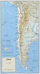
| Description | Shaded relief map of Chile. |
| Source | http://www.lib.utexas.edu/maps/chile.html |
| Author | Central Intelligence Agency |
Licensing
| This image is a work of a Central Intelligence Agency employee, taken or made as part of that person's official duties. As a Work of the United States Government, this image or media is in the public domain in the United States.
|

|
Original upload log
| Date/Time | Dimensions | User | Comment |
|---|---|---|---|
| 27 October 2005, 19:06:32 | 803 × 1456 (306378 bytes) | Brian0918 (talk · contribs) | Shaded relief map of Chile. http://www.lib.utexas.edu/maps/chile.html {{PD-USGov-CIA}} [[Category:Maps of Chile]] |
File history
Click on a date/time to view the file as it appeared at that time.
| Date/Time | Thumbnail | Dimensions | User | Comment | |
|---|---|---|---|---|---|
| current | 04:03, 22 November 2014 | | 803 × 1,456 (366 KB) | GifTagger | Bot: Converting file to superior PNG file. (Source: Chile_relief_map_1974.gif). This GIF was problematic due to non-greyscale color table. |
File usage
The following pages on the English Wikipedia use this file (pages on other projects are not listed):
Global file usage
The following other wikis use this file:
- Usage on de.wikipedia.org
- Usage on es.wikipedia.org
- Usage on fr.wikipedia.org
- Usage on fr.wikinews.org
- Usage on hr.wiktionary.org
- Usage on it.wikipedia.org
- Usage on ja.wikipedia.org
- Usage on ka.wikipedia.org
- Usage on uk.wikipedia.org
- Usage on zh.wikipedia.org