
File:Cook Street Gate, Coventry - geograph.org.uk - 1076525.jpg
Size of this preview: 450 × 600 pixels. Other resolutions: 180 × 240 pixels | 480 × 640 pixels.
Original file (480 × 640 pixels, file size: 95 KB, MIME type: image/jpeg)
| This is a file from the Wikimedia Commons. Information from its description page there is shown below. Commons is a freely licensed media file repository. You can help. |
Summary
| Description |
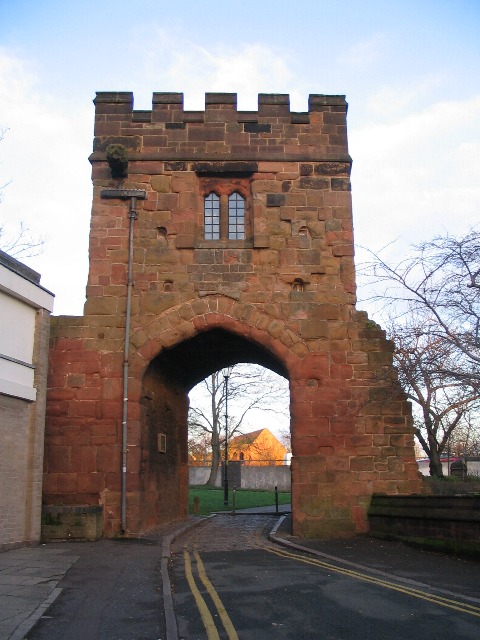
English: Cook Street Gate, Coventry A grade I listed building, one of two surviving gates of the original twelve on Coventry's city wall[1]. Much of the wall was demolished after the Civil War, but the gates survived to the 18th century when all but the present two were removed. Cook Street gate dates from the 15th century and stands over a road which once led to Harnall. Used as a dwelling house in the 19th century, it was presented to the city in 1913 and restored in 1918 when the crenellations were added.
Source: 'A Guide to the Buildings of Coventry', George Demidowicz The narrow road it spans is cut off by the ring road, the wall of which can be seen through the arch, as can the sandstone St Mark's church on Stoney Stanton Road beyond. |
| Date | |
| Source | From geograph.org.uk |
| Author | E Gammie |
| Attribution (required by the license) | E Gammie / Cook Street Gate, Coventry / |
| Camera location | | View this and other nearby images on: OpenStreetMap |
|---|
_heading:45.00&language=en)
| Object location | | View this and other nearby images on: OpenStreetMap |
|---|
_heading:45.00&language=en)
Licensing

|
This image was taken from the Geograph project collection. See this photograph's page on the Geograph website for the photographer's contact details. The copyright on this image is owned by E Gammie and is licensed for reuse under the Creative Commons Attribution-ShareAlike 2.0 license.
|
This file is licensed under the Creative Commons Attribution-Share Alike 2.0 Generic license.
Attribution: E Gammie
- You are free:
- to share – to copy, distribute and transmit the work
- to remix – to adapt the work
- Under the following conditions:
- attribution – You must give appropriate credit, provide a link to the license, and indicate if changes were made. You may do so in any reasonable manner, but not in any way that suggests the licensor endorses you or your use.
- share alike – If you remix, transform, or build upon the material, you must distribute your contributions under the same or compatible license as the original.
File history
Click on a date/time to view the file as it appeared at that time.
| Date/Time | Thumbnail | Dimensions | User | Comment | |
|---|---|---|---|---|---|
| current | 07:01, 24 February 2011 | | 480 × 640 (95 KB) | GeographBot | == {{int:filedesc}} == {{Information |description={{en|1=Cook Street Gate, Coventry A grade I listed building, one of two surviving gates of the original twelve on Coventry's city wall[1]. Much of the wall was demolished after the Civil War, but the gate |
File usage
The following pages on the English Wikipedia use this file (pages on other projects are not listed):
Global file usage
The following other wikis use this file:
- Usage on ru.wikipedia.org
- Usage on www.wikidata.org