
File:Cornwall Coliseum - geograph.org.uk - 1238029.jpg
No higher resolution available.
Cornwall_Coliseum_-_geograph.org.uk_-_1238029.jpg (640 × 480 pixels, file size: 106 KB, MIME type: image/jpeg)
| This is a file from the Wikimedia Commons. Information from its description page there is shown below. Commons is a freely licensed media file repository. You can help. |
Summary
| Description |
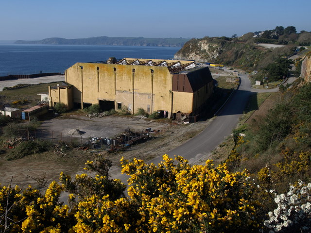
English: Cornwall Coliseum. The remains of a once major venue, also shown in 1212381 and 495309. They were taken two and three years ago, and things still look bleak. "The venue started as a country club in the 1930's seeing many wealthy visitors, including King Edward VIII, who visited the Riviera Club, as it was a very fashionable destination at that time" http://www.cornwallcoliseum.co.uk/ . Even while functioning in the 1990s, the building was described thus: "the hideous entertainment multiplex modestly named the Cornwall Coliseum is an ideal Led Zeppelin venue. It squats grimly on a granite beach a matter of feet from the Atlantic ocean. It is featureless, implacable, massy yet compacted, as if dropped on Cornwall from a great height: corrugated concrete blocks set against black cliffs and a riffing sea." https://www.independent.co.uk/arts-entertainment/page--plant--cornwall-coliseum-st-austell-1592476.html |
| Date | |
| Source | From geograph.org.uk |
| Author | Derek Harper |
| Attribution (required by the license) | Derek Harper / Cornwall Coliseum / |
| Camera location | | View this and other nearby images on: OpenStreetMap |
|---|
_heading:225.00&language=en)
| Object location | | View this and other nearby images on: OpenStreetMap |
|---|
_heading:225.00&language=en)
Licensing

|
This image was taken from the Geograph project collection. See this photograph's page on the Geograph website for the photographer's contact details. The copyright on this image is owned by Derek Harper and is licensed for reuse under the Creative Commons Attribution-ShareAlike 2.0 license.
|
This file is licensed under the Creative Commons Attribution-Share Alike 2.0 Generic license.
Attribution: Derek Harper
- You are free:
- to share – to copy, distribute and transmit the work
- to remix – to adapt the work
- Under the following conditions:
- attribution – You must give appropriate credit, provide a link to the license, and indicate if changes were made. You may do so in any reasonable manner, but not in any way that suggests the licensor endorses you or your use.
- share alike – If you remix, transform, or build upon the material, you must distribute your contributions under the same or compatible license as the original.
File history
Click on a date/time to view the file as it appeared at that time.
| Date/Time | Thumbnail | Dimensions | User | Comment | |
|---|---|---|---|---|---|
| current | 12:50, 26 February 2011 | | 640 × 480 (106 KB) | GeographBot | == {{int:filedesc}} == {{Information |description={{en|1=Cornwall Coliseum The remains of a once major venue, also shown in 1212381 and 495309. They were taken two and three years ago, and things still look bleak. "The venue started as a country c |
File usage
The following pages on the English Wikipedia use this file (pages on other projects are not listed):