
File:Dersingham Railway Station.jpg
No higher resolution available.
Dersingham_Railway_Station.jpg (640 × 480 pixels, file size: 97 KB, MIME type: image/jpeg)
| This is a file from the Wikimedia Commons. Information from its description page there is shown below. Commons is a freely licensed media file repository. You can help. |
Summary
| Description |
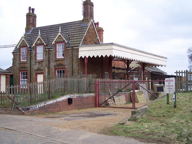
English: Former Dersingham Station, Norfolk In 1862 the Lynn & Hunstanton Railway (L&HR) opened a line connecting King's Lynn and Hunstanton. It merged with the West Norfolk Junction Railway in 1874 to form the Hunstanton & West Norfolk Railway which in turn was absorbed by the Great Eastern Railway in 1890. At the grouping in 1923 it came under the control of the LNER and BR closed it to all traffic on 5 May 1969. At Dersingham, midway between the two towns, the station house, both platforms, buildings, canopies and signal box survive intact, in use as offices and stores for Semba Trading (builder's merchant's). |
| Date | |
| Source | From geograph.org.uk |
| Author | Ralph Rawlinson |
| Permission (Reusing this file) |
Creative Commons Attribution Share-alike license 2.0 |
| Object location | | View this and other nearby images on: OpenStreetMap |
|---|
_region:GB-GBN_heading:135.00&language=en)
Licensing

|
This image was taken from the Geograph project collection. See this photograph's page on the Geograph website for the photographer's contact details. The copyright on this image is owned by Ralph Rawlinson and is licensed for reuse under the Creative Commons Attribution-ShareAlike 2.0 license.
|
This file is licensed under the Creative Commons Attribution-Share Alike 2.0 Generic license.
Attribution: Ralph Rawlinson
- You are free:
- to share – to copy, distribute and transmit the work
- to remix – to adapt the work
- Under the following conditions:
- attribution – You must give appropriate credit, provide a link to the license, and indicate if changes were made. You may do so in any reasonable manner, but not in any way that suggests the licensor endorses you or your use.
- share alike – If you remix, transform, or build upon the material, you must distribute your contributions under the same or compatible license as the original.
File history
Click on a date/time to view the file as it appeared at that time.
| Date/Time | Thumbnail | Dimensions | User | Comment | |
|---|---|---|---|---|---|
| current | 20:43, 5 July 2008 | | 640 × 480 (97 KB) | Lamberhurst | {{geograph|172882|Ralph Rawlinson}} Former Dersingham Station, Norfolk. Category:Disused railway stations in England {{ImageUpload|basic}} |
File usage
The following pages on the English Wikipedia use this file (pages on other projects are not listed):
Global file usage
The following other wikis use this file:
- Usage on www.wikidata.org