
File:Ditchingham Railway Station Site.jpg
No higher resolution available.
Ditchingham_Railway_Station_Site.jpg (640 × 480 pixels, file size: 65 KB, MIME type: image/jpeg)
| This is a file from the Wikimedia Commons. Information from its description page there is shown below. Commons is a freely licensed media file repository. You can help. |
Summary
| Description |
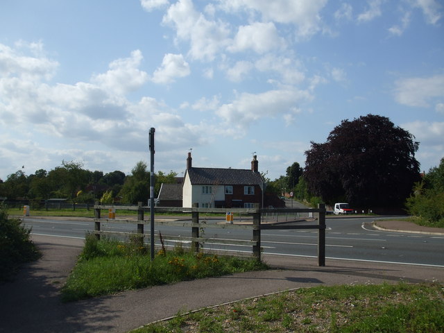
English: The Site of Ditchingham Railway station The station was on the Waveney Valley railway. It had a small station building,goods shed, signal box and sidings. The station was about where the junction was, the house as can be seen still survives. The line closed in the 1960s, the trackbed from Ellingham to Homersfield is now a road. |
| Date | |
| Source | From geograph.org.uk |
| Author | Ashley Dace |
| Permission (Reusing this file) |
Creative Commons Attribution Share-alike license 2.0 |
| Attribution (required by the license) | Ashley Dace / The Site of Ditchingham Railway station / |
| Camera location | | View this and other nearby images on: OpenStreetMap |
|---|
Licensing

|
This image was taken from the Geograph project collection. See this photograph's page on the Geograph website for the photographer's contact details. The copyright on this image is owned by Ashley Dace and is licensed for reuse under the Creative Commons Attribution-ShareAlike 2.0 license.
|
This file is licensed under the Creative Commons Attribution-Share Alike 2.0 Generic license.
Attribution: Ashley Dace
- You are free:
- to share – to copy, distribute and transmit the work
- to remix – to adapt the work
- Under the following conditions:
- attribution – You must give appropriate credit, provide a link to the license, and indicate if changes were made. You may do so in any reasonable manner, but not in any way that suggests the licensor endorses you or your use.
- share alike – If you remix, transform, or build upon the material, you must distribute your contributions under the same or compatible license as the original.
Original upload log
The original description page was here. All following user names refer to en.wikipedia.
- 2009-11-24 12:40 Dace83 640×480× (66388 bytes) == Summary == {{Information |Description=The Site of Ditchingham Railway station |Source=From [https://www.geograph.org.uk/photo/1426925 geograph.org.uk] |Date=2009-08-03 |Author=[https://www.geograph.org.uk/profile/29497 Ashley Dace] |Permission=Creative C
File history
Click on a date/time to view the file as it appeared at that time.
| Date/Time | Thumbnail | Dimensions | User | Comment | |
|---|---|---|---|---|---|
| current | 16:51, 8 December 2009 | | 640 × 480 (65 KB) | Angusmclellan | == Summary == {{Information |Description=The Site of Ditchingham Railway station |Source=From [http://www.geograph.org.uk/photo/1426925 geograph.org.uk] |Date=2009-08-03 |Author=[http://www.geograph.org.uk/profile/29497 Ashley Dace] |Permission=Creative C |
File usage
The following pages on the English Wikipedia use this file (pages on other projects are not listed):
Global file usage
The following other wikis use this file:
- Usage on www.wikidata.org