
File:Elphinstone Tower (25565323455).jpg
Original file (3,980 × 5,986 pixels, file size: 17.66 MB, MIME type: image/jpeg)
| This is a file from the Wikimedia Commons. Information from its description page there is shown below. Commons is a freely licensed media file repository. You can help. |
.jpg)
Summary
| Description |
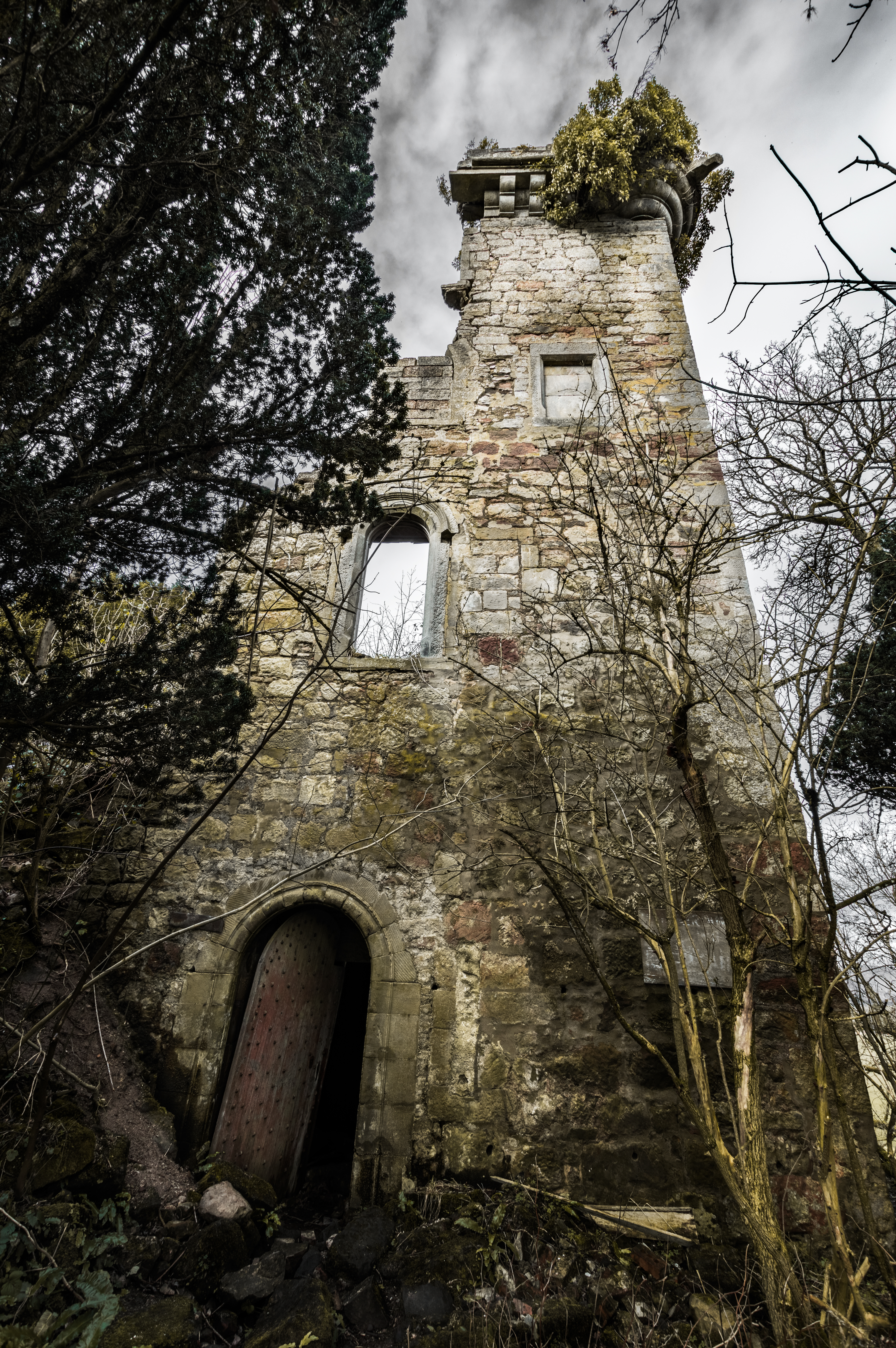
The crumbling remains of Elphinstone Tower tucked away in the woods of Dunmore Estate. The tower was last used as a burial vault and when you go inside it is kinda like a doocot except the holes are bigger, for human bodies rather than doos. Freaky. Here is a bit about the tower and it's history. Elphinstone Tower, also known as Dunmore Tower or Airth Tower, is a ruined tower house on the Dunmore Estate in central Scotland. It is located 1.5 kilometres (0.93 mi) north-west of Airth and 9 kilometres (5.6 mi) east of Stirling in the Falkirk council area. The 16th-century ruin is protected as a category C(S) listed building. History The tower dates to the early 16th century, when it was built by Sir John Elphinstone as the seat of the barony of Elphinstone. The Elphinstone Estate was purchased for £16,000 by John Murray, son of the 3rd Earl of Dunmore, in 1754. Two years later he inherited the earldom, and renamed the estate Dunmore after his title. Lord Dunmore built the famous Dunmore Pineapple elsewhere on the estate in 1761. The tower was extended at some point, although there is little evidence that it was occupied. In the 1820s the 5th Earl commissioned the building of Dunmore Park as the principal residence on the estate. The additions to the tower were demolished to allow construction of St Andrew's Episcopal Church, a private chapel completed around 1850. The tower was subsequently restored and the ground floor remodelled as a family burial vault. The Murray family left Dunmore in 1911, and the tower has since decayed. St Andrew's Church was demolished in the early 1960s, and the north-west angle of the tower collapsed after a storm around 1968. The tower stands 9 by 7.4 metres (30 by 24 ft), and the walls are 17 metres (56 ft) high to the parapet. Source:en.wikipedia.org |
| Date | |
| Source | Elphinstone Tower |
| Author | Neil Williamson from Dundee, Scotland |
| Camera location | | View this and other nearby images on: OpenStreetMap |
|---|
.jpg¶ms=056.080244_N_-003.784790_E_globe:Earth_type:camera_source:Flickr_&language=en)
Licensing
- You are free:
- to share – to copy, distribute and transmit the work
- to remix – to adapt the work
- Under the following conditions:
- attribution – You must give appropriate credit, provide a link to the license, and indicate if changes were made. You may do so in any reasonable manner, but not in any way that suggests the licensor endorses you or your use.
- share alike – If you remix, transform, or build upon the material, you must distribute your contributions under the same or compatible license as the original.
| This image was originally posted to Flickr by Neillwphoto at https://flickr.com/photos/61629383@N08/25565323455. It was reviewed on 2 May 2021 by FlickreviewR 2 and was confirmed to be licensed under the terms of the cc-by-sa-2.0. |
File history
Click on a date/time to view the file as it appeared at that time.
| Date/Time | Thumbnail | Dimensions | User | Comment | |
|---|---|---|---|---|---|
| current | 15:38, 2 May 2021 | | 3,980 × 5,986 (17.66 MB) | Belbury | Transferred from Flickr via #flickr2commons |
.jpg)