
File:Fore Street, Ivybridge - geograph.org.uk - 1410954.jpg
No higher resolution available.
Fore_Street,_Ivybridge_-_geograph.org.uk_-_1410954.jpg (640 × 442 pixels, file size: 65 KB, MIME type: image/jpeg)
| This is a file from the Wikimedia Commons. Information from its description page there is shown below. Commons is a freely licensed media file repository. You can help. |
Summary
| Description |
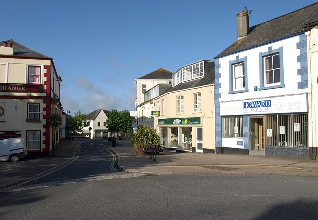
English: Fore Street, Ivybridge. A very similar view to 880629 from the bridge over the Erme. On the left is the Exchange. "The Kings Arms, now the Exchange public house, received its licence to trade in 1832 from Sir John Rogers. Unfortunately the open mill leat serving the lower mills ran immediately outside the inn door. Customers leaving the premises had difficulty in avoiding this. Despite the publican's protests to the mill owners it remained uncovered. The public house was rebuilt and substantially changed in 1891." http://www.burrows.co.uk/ivybridge/03TheM.htm |
| Date | |
| Source | From geograph.org.uk |
| Author | Derek Harper |
| Attribution (required by the license) | Derek Harper / Fore Street, Ivybridge / |
| Camera location | | View this and other nearby images on: OpenStreetMap |
|---|
_heading:202.00&language=en)
| Object location | | View this and other nearby images on: OpenStreetMap |
|---|
_heading:202.00&language=en)
Licensing

|
This image was taken from the Geograph project collection. See this photograph's page on the Geograph website for the photographer's contact details. The copyright on this image is owned by Derek Harper and is licensed for reuse under the Creative Commons Attribution-ShareAlike 2.0 license.
|
This file is licensed under the Creative Commons Attribution-Share Alike 2.0 Generic license.
Attribution: Derek Harper
- You are free:
- to share – to copy, distribute and transmit the work
- to remix – to adapt the work
- Under the following conditions:
- attribution – You must give appropriate credit, provide a link to the license, and indicate if changes were made. You may do so in any reasonable manner, but not in any way that suggests the licensor endorses you or your use.
- share alike – If you remix, transform, or build upon the material, you must distribute your contributions under the same or compatible license as the original.
File history
Click on a date/time to view the file as it appeared at that time.
| Date/Time | Thumbnail | Dimensions | User | Comment | |
|---|---|---|---|---|---|
| current | 15:49, 1 March 2011 | | 640 × 442 (65 KB) | GeographBot | == {{int:filedesc}} == {{Information |description={{en|1=Fore Street, Ivybridge A very similar view to 880629 from the bridge over the Erme. On the left is the Exchange. "The Kings Arms, now the Exchange public house, received its licence to trade in |
File usage
The following pages on the English Wikipedia use this file (pages on other projects are not listed):