
File:Former railway station, Llanidloes (geograph 1469638).jpg
No higher resolution available.
Former_railway_station,_Llanidloes_(geograph_1469638).jpg (640 × 423 pixels, file size: 106 KB, MIME type: image/jpeg)
| This is a file from the Wikimedia Commons. Information from its description page there is shown below. Commons is a freely licensed media file repository. You can help. |
.jpg)
Summary
| Description |
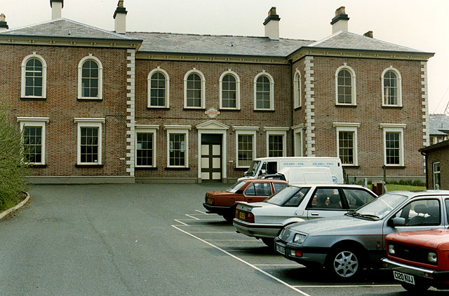
English: Former railway station, Llanidloes As the railways rather belatedly spread into mid-Wales, Llanidloes seemed destined to become the meeting point of three of them, namely the Newtown and Llanidloes from the north, the Mid Wales from the south, and the Manchester and Milford from the south west. Consequently by agreement the Newtown and Llanidloes built this imposing station building to house the offices of the three companies. It also extended its line a short distance to the south to Penpompren to meet the lines of the other two companies. In the event, the Manchester and Milford failed to complete its line over the Cambrian mountains and never used the station, while the Newtown and Llanidloes joined with other lines to form the Cambrian Railways, with its headquarters in Oswestry, so the building was rather underused, particularily after the Cambrian absorbed the Mid Wales some years later. Llanidloes lost its passenger service and also the line to the south in 1962, with the northern line used for some freight until closed in 1967. Thereafter the building was left idle, until splendidly restored in 1984 to house local offices and businesses. |
| Date | |
| Source | From geograph.org.uk |
| Author | Nigel Brown |
| Permission (Reusing this file) |
Creative Commons Attribution Share-alike license 2.0 |
| Camera location | | View this and other nearby images on: OpenStreetMap |
|---|
.jpg¶ms=052.447920_N_-003.536965_E_globe:Earth_type:camera_heading:135.00&language=en)
Licensing

|
This image was taken from the Geograph project collection. See this photograph's page on the Geograph website for the photographer's contact details. The copyright on this image is owned by Nigel Brown and is licensed for reuse under the Creative Commons Attribution-ShareAlike 2.0 license.
|
This file is licensed under the Creative Commons Attribution-Share Alike 2.0 Generic license.
Attribution: Nigel Brown
- You are free:
- to share – to copy, distribute and transmit the work
- to remix – to adapt the work
- Under the following conditions:
- attribution – You must give appropriate credit, provide a link to the license, and indicate if changes were made. You may do so in any reasonable manner, but not in any way that suggests the licensor endorses you or your use.
- share alike – If you remix, transform, or build upon the material, you must distribute your contributions under the same or compatible license as the original.
File history
Click on a date/time to view the file as it appeared at that time.
| Date/Time | Thumbnail | Dimensions | User | Comment | |
|---|---|---|---|---|---|
| current | 16:37, 5 December 2010 | | 640 × 423 (106 KB) | Flying Stag | {{Information |Description={{en|1=Old Railway Station, Llanidloes, Powys}} |Source=Geograph-1469638-by-Nigel-Brown |Author=Nigel Brown |Date=August 1990 |Permission= |other_versions= }} |
File usage
The following pages on the English Wikipedia use this file (pages on other projects are not listed):
.jpg)