
File:Frezier Voyage Detroit de Maire.jpg

Size of this preview: 417 × 599 pixels. Other resolutions: 167 × 240 pixels | 334 × 480 pixels | 534 × 768 pixels | 712 × 1,024 pixels | 1,666 × 2,394 pixels.
Original file (1,666 × 2,394 pixels, file size: 948 KB, MIME type: image/jpeg)
| This is a file from the Wikimedia Commons. Information from its description page there is shown below. Commons is a freely licensed media file repository. You can help. |
Summary
| Description |
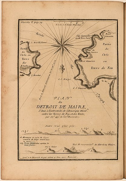
English: Plan of the Le Maire Strait or Estrecho de le Maire between Tierra del Fuego in present-day Argentina and Isla de los Estados. Includes profiles of the shore, compass rose, scale and identification of capes and bays.
Español: Mapa imprimido demuestra el Estrecho de Le Maire entre Argentina y Isla de los Estados. Incluye la costa, un compás, escala, y identificación de detalles geográficos. |
| Date | |
| Source | A voyage to the South-sea, and along the coasts of Chili and Peru, in the years 1712, 1713, and 1714. London: 1717. https://jcb.lunaimaging.com/luna/servlet/view/search/when/1717?q=E717+F896v&sort=normalized_date%2Cfile_name%2Csource_author%2Csource_title |
| Author | Amédée François Frézier |
Licensing
|
This work is in the public domain in its country of origin and other countries and areas where the copyright term is the author's life plus 100 years or fewer. | |
| This file has been identified as being free of known restrictions under copyright law, including all related and neighboring rights. | |
File history
Click on a date/time to view the file as it appeared at that time.
| Date/Time | Thumbnail | Dimensions | User | Comment | |
|---|---|---|---|---|---|
| current | 21:01, 18 October 2019 | | 1,666 × 2,394 (948 KB) | Gpcantu | User created page with UploadWizard |
File usage
The following pages on the English Wikipedia use this file (pages on other projects are not listed):
Global file usage
The following other wikis use this file:
- Usage on es.wikipedia.org
- Usage on pt.wikipedia.org