
File:Goldsmith's Inlet.jpg

Original file (4,000 × 3,000 pixels, file size: 5.09 MB, MIME type: image/jpeg)
| This is a file from the Wikimedia Commons. Information from its description page there is shown below. Commons is a freely licensed media file repository. You can help. |
Summary
| Description |
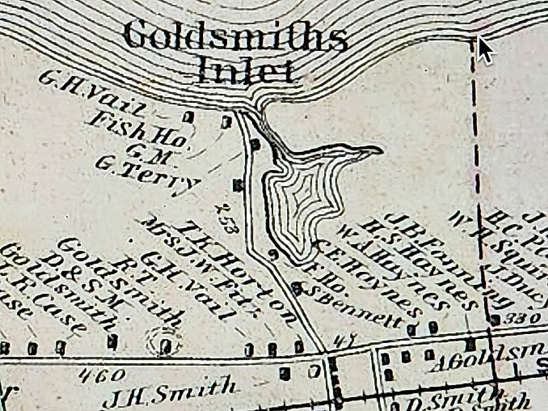
English: Detail of Beers 1873 Long Island Map showing the tidal pond and property names, with GM indicating Grist Mill. |
| Date | |
| Source | https://upload.wikimedia.org/wikipedia/commons/8/8b/1873_Beers_Map_of_Southold_%5E_Shelter_Island%2C_Long_Island%2C_New_York_-_Geographicus_-_Southold_Shelter_Island2-beers-1873.jpg |
| Author | Beers |
Fredrick W. Beers’ Map of Southold and Shelter Island, Long Island, New York. Published in 1873, this magnificent map covers from Franklinville and Mattituck Hills eastward past Cutchogue harbor, Peconic Village, Great Hog Neck Southold, Greenport, Orient Point and Oyster ponds to Plum Island. Includes all of Shelter Island in superb detail. An inset map in the lower left depicts Gardiners Bay, Plum Island and Gull Island. Another inset in the lower right quadrant details the village of North Greenport. Beers maps are highly desirable for their superb detail down to the level of individual buildings and household family names. Shelter Island for example denotes the large properties and households of Doctor B. Nicoll, Professor E. N. Horsford, J. H. Tuthill, S. K. Cartwright, M. D. Loper and many others. Prepared by Beers, Comstock & Cline out of their office at 36 Vesey Street, New York City, for inclusion in the first published atlas of Long Island, the 1873 issue of Atlas of Long Island, New York. Date 1873 (undated)
Licensing
|
This work is in the public domain in its country of origin and other countries and areas where the copyright term is the author's life plus 70 years or fewer. This work is in the public domain in the United States because it was published (or registered with the U.S. Copyright Office) before January 1, 1929. | |
| This file has been identified as being free of known restrictions under copyright law, including all related and neighboring rights. | |
File history
Click on a date/time to view the file as it appeared at that time.
| Date/Time | Thumbnail | Dimensions | User | Comment | |
|---|---|---|---|---|---|
| current | 22:41, 4 March 2023 | | 4,000 × 3,000 (5.09 MB) | CaptJayRuffins | Uploaded a work by Beers from https://upload.wikimedia.org/wikipedia/commons/8/8b/1873_Beers_Map_of_Southold_%5E_Shelter_Island%2C_Long_Island%2C_New_York_-_Geographicus_-_Southold_Shelter_Island2-beers-1873.jpg with UploadWizard |