
File:Holt railway station (site), Norfolk (geograph 5017525).jpg

Size of this preview: 800 × 600 pixels. Other resolutions: 320 × 240 pixels | 640 × 480 pixels | 1,024 × 768 pixels | 1,280 × 960 pixels | 1,600 × 1,200 pixels.
Original file (1,600 × 1,200 pixels, file size: 461 KB, MIME type: image/jpeg)
| This is a file from the Wikimedia Commons. Information from its description page there is shown below. Commons is a freely licensed media file repository. You can help. |
,_Norfolk_(geograph_5017525).jpg)
Summary
| Description |
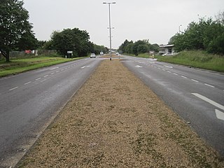
English: Holt railway station (site), Norfolk Opened in 1884 on what became part of the Midland and Great Northern Railways' joint line across North Norfolk from Melton Constable to Yarmouth via Sheringham. From 1884 to 1887 it was a terminus from Melton Constable, until the line was extended. The line and station closed in 1964 and all trace was erased by the building of the A148 Holt by-pass. View south west towards Melton Constable taken from approximately the site of the former level crossing. The North Norfolk Railway opened a replacement Holt station in 1987 - see TG0939 : Holt NNR railway station, Norfolk. |
| Date | |
| Source | From geograph.org.uk |
| Author | Nigel Thompson |
| Permission (Reusing this file) |
Creative Commons Attribution Share-alike license 2.0 |
| Attribution (required by the license) | Nigel Thompson / Holt railway station (site), Norfolk / |
.jpg)
| Camera location | | View this and other nearby images on: OpenStreetMap |
|---|
,_Norfolk_(geograph_5017525).jpg¶ms=052.904036_N_0001.094365_E_globe:Earth_type:camera_source:geograph-osgb36(TG08203855)_heading:247.00&language=en)
| Object location | | View this and other nearby images on: OpenStreetMap |
|---|
,_Norfolk_(geograph_5017525).jpg¶ms=052.903790_N_0001.093310_E_globe:Earth_class:object_type:object_source:geograph-osgb36(TG08133852)_heading:247.00&language=en)
Licensing

|
This image was taken from the Geograph project collection. See this photograph's page on the Geograph website for the photographer's contact details. The copyright on this image is owned by Nigel Thompson and is licensed for reuse under the Creative Commons Attribution-ShareAlike 2.0 license.
|
This file is licensed under the Creative Commons Attribution-Share Alike 2.0 Generic license.
Attribution: Nigel Thompson
- You are free:
- to share – to copy, distribute and transmit the work
- to remix – to adapt the work
- Under the following conditions:
- attribution – You must give appropriate credit, provide a link to the license, and indicate if changes were made. You may do so in any reasonable manner, but not in any way that suggests the licensor endorses you or your use.
- share alike – If you remix, transform, or build upon the material, you must distribute your contributions under the same or compatible license as the original.
File history
Click on a date/time to view the file as it appeared at that time.
| Date/Time | Thumbnail | Dimensions | User | Comment | |
|---|---|---|---|---|---|
| current | 14:17, 25 December 2019 | | 1,600 × 1,200 (461 KB) | Lamberhurst | Transferred from geograph.co.uk using [https://tools.wmflabs.org/geograph2commons/ geograph2commons] |
File usage
The following pages on the English Wikipedia use this file (pages on other projects are not listed):
Global file usage
The following other wikis use this file:
,_Norfolk_(geograph_5017525).jpg)