
File:Isaberrysaura map.jpg
Size of this preview: 691 × 600 pixels. Other resolutions: 276 × 240 pixels | 553 × 480 pixels | 926 × 804 pixels.
Original file (926 × 804 pixels, file size: 232 KB, MIME type: image/jpeg)
| This is a file from the Wikimedia Commons. Information from its description page there is shown below. Commons is a freely licensed media file repository. You can help. |
Summary
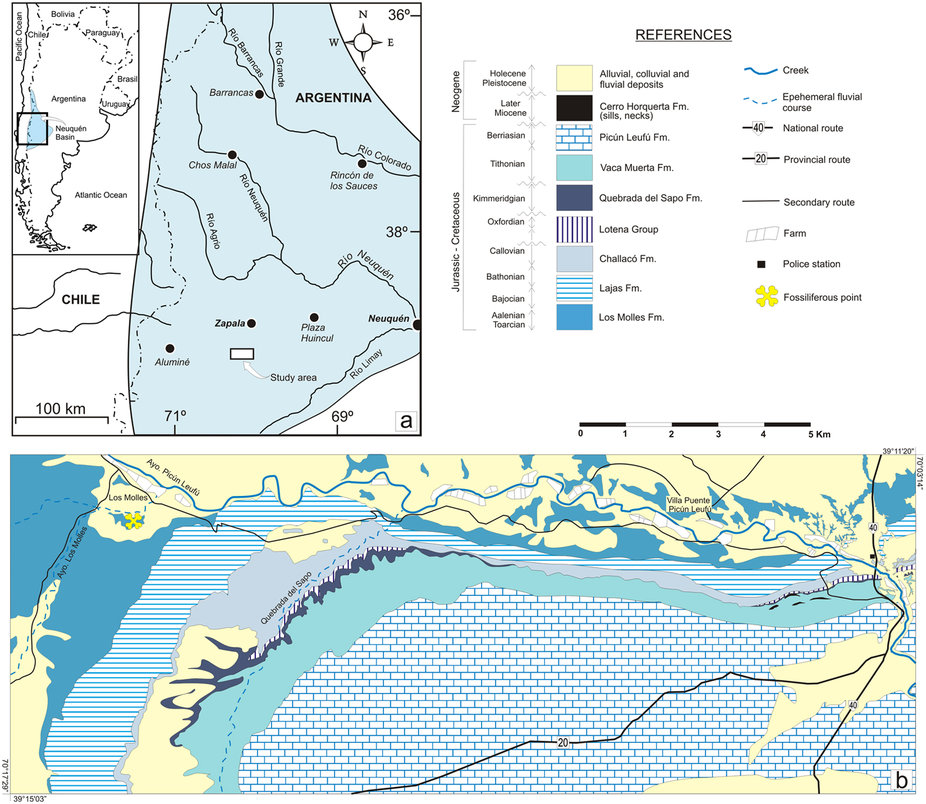
| Description | Geological map showing the type locality of Isaberrysaura mollensis gen. et sp. nov. The map was made by Alberto C. Garrido on the basis of a LANDSAT satellite image available in the Dirección Provincial de Minería (the institution where A.C.G. works) using Adobe Photoshop CS2 Serial Number: 1045-1412-5685-1654-6343-1431. |
| Date | |
| Source | http://www.nature.com/articles/srep42778 |
| Author | Leonardo Salgado, José I. Canudo, Alberto C. Garrido, Miguel Moreno-Azanza, Leandro C. A. Martínez, Rodolfo A. Coria & José M. Gasca |
Licensing
This file is licensed under the Creative Commons Attribution 4.0 International license.
- You are free:
- to share – to copy, distribute and transmit the work
- to remix – to adapt the work
- Under the following conditions:
- attribution – You must give appropriate credit, provide a link to the license, and indicate if changes were made. You may do so in any reasonable manner, but not in any way that suggests the licensor endorses you or your use.
File history
Click on a date/time to view the file as it appeared at that time.
| Date/Time | Thumbnail | Dimensions | User | Comment | |
|---|---|---|---|---|---|
| current | 18:40, 21 February 2017 | | 926 × 804 (232 KB) | FunkMonk | =={{int:filedesc}}== {{Information |description=Geological map showing the type locality of Isaberrysaura mollensis gen. et sp. nov. The map was made by Alberto C. Garrido on the basis of a LANDSAT satellite image available in the Dirección Provincial... |
File usage
The following pages on the English Wikipedia use this file (pages on other projects are not listed):
Global file usage
The following other wikis use this file:
- Usage on es.wikipedia.org
- Usage on it.wikipedia.org
- Usage on nl.wikipedia.org
- Usage on www.wikidata.org
- Usage on zh.wikipedia.org