
File:Island I Vow - geograph.org.uk - 1041594.jpg
No higher resolution available.
Island_I_Vow_-_geograph.org.uk_-_1041594.jpg (640 × 480 pixels, file size: 82 KB, MIME type: image/jpeg)
| This is a file from the Wikimedia Commons. Information from its description page there is shown below. Commons is a freely licensed media file repository. You can help. |
Summary
| Description |
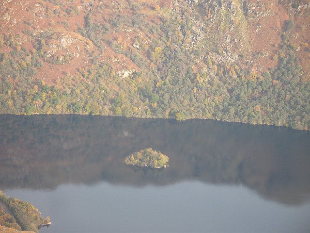
English: Island I Vow A small wooded island in the middle of the narrow upper Loch Lomond, which is quite an unusual place for an island, narrow lochs with steep sides are usually deep, as Loch Lomond is near here. The island was once home to a castle, inhabited up to the 18th century and was a stronghold of the notorious MacFarlanes. Today a single yellow kayak, was moored on its southern shore
Beyond the island, the slopes of Beinn a' Choin plunge deeply into the loch, heightening the mystery of the island. View from the Little Hills of Ben Vorlich. |
| Date | |
| Source | From geograph.org.uk |
| Author | Richard Webb |
| Attribution (required by the license) | Richard Webb / Island I Vow / |
| Camera location | | View this and other nearby images on: OpenStreetMap |
|---|
_heading:90.00&language=en)
| Object location | | View this and other nearby images on: OpenStreetMap |
|---|
_heading:90.00&language=en)
Licensing

|
This image was taken from the Geograph project collection. See this photograph's page on the Geograph website for the photographer's contact details. The copyright on this image is owned by Richard Webb and is licensed for reuse under the Creative Commons Attribution-ShareAlike 2.0 license.
|
This file is licensed under the Creative Commons Attribution-Share Alike 2.0 Generic license.
Attribution: Richard Webb
- You are free:
- to share – to copy, distribute and transmit the work
- to remix – to adapt the work
- Under the following conditions:
- attribution – You must give appropriate credit, provide a link to the license, and indicate if changes were made. You may do so in any reasonable manner, but not in any way that suggests the licensor endorses you or your use.
- share alike – If you remix, transform, or build upon the material, you must distribute your contributions under the same or compatible license as the original.
File history
Click on a date/time to view the file as it appeared at that time.
| Date/Time | Thumbnail | Dimensions | User | Comment | |
|---|---|---|---|---|---|
| current | 21:35, 23 February 2011 | | 640 × 480 (82 KB) | GeographBot | == {{int:filedesc}} == {{Information |description={{en|1=Island I Vow A small wooded island in the middle of the narrow upper Loch Lomond, which is quite an unusual place for an island, narrow lochs with steep sides are usually deep, as Loch Lomond is nea |
File usage
The following pages on the English Wikipedia use this file (pages on other projects are not listed):
Global file usage
The following other wikis use this file:
- Usage on da.wikipedia.org
- Usage on ga.wikipedia.org
- Usage on gd.wikipedia.org
- Usage on www.wikidata.org