
File:Kensworth Chalk Quarry - geograph.org.uk - 1175264.jpg
No higher resolution available.
Kensworth_Chalk_Quarry_-_geograph.org.uk_-_1175264.jpg (640 × 394 pixels, file size: 187 KB, MIME type: image/jpeg)
| This is a file from the Wikimedia Commons. Information from its description page there is shown below. Commons is a freely licensed media file repository. You can help. |
Summary
| Description |
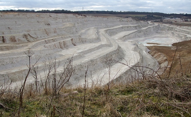
English: Kensworth Chalk Quarry, near to Church End, Bedfordshire, Great Britain.
This is a close-up of part of the quarry seen in <a href="https://www.geograph.org.uk/photo/1175259">TL0219 : Kensworth Chalk Quarry Panorama</a>. If you look closely near the top of the quarry about 1/5 of the way from the left side of the photo, you may be able to make out a little yellowish object. This is in fact an enormous earth moving vehicle - about half as big again as a double decker bus - this will give an idea of the scale of this mammoth pit. |
| Date | |
| Source | From geograph.org.uk; transferred by User:Skinsmoke using geograph_org2commons. |
| Author | Rob Farrow |
| Permission (Reusing this file) |
Creative Commons Attribution Share-alike license 2.0 |
| Attribution (required by the license) | Rob Farrow / Kensworth Chalk Quarry / |
| Camera location | | View this and other nearby images on: OpenStreetMap |
|---|
| Object location | | View this and other nearby images on: OpenStreetMap |
|---|
_region:GB-ENG_heading:247.00&language=en)
Licensing

|
This image was taken from the Geograph project collection. See this photograph's page on the Geograph website for the photographer's contact details. The copyright on this image is owned by Rob Farrow and is licensed for reuse under the Creative Commons Attribution-ShareAlike 2.0 license.
|
This file is licensed under the Creative Commons Attribution-Share Alike 2.0 Generic license.
Attribution: Rob Farrow
- You are free:
- to share – to copy, distribute and transmit the work
- to remix – to adapt the work
- Under the following conditions:
- attribution – You must give appropriate credit, provide a link to the license, and indicate if changes were made. You may do so in any reasonable manner, but not in any way that suggests the licensor endorses you or your use.
- share alike – If you remix, transform, or build upon the material, you must distribute your contributions under the same or compatible license as the original.
File history
Click on a date/time to view the file as it appeared at that time.
| Date/Time | Thumbnail | Dimensions | User | Comment | |
|---|---|---|---|---|---|
| current | 02:02, 27 October 2010 | | 640 × 394 (187 KB) | File Upload Bot (Magnus Manske) |
File usage
The following pages on the English Wikipedia use this file (pages on other projects are not listed):
Global file usage
The following other wikis use this file:
- Usage on www.wikidata.org