
File:Kirriemuir Alberta Grain Elevator (9627306600).jpg

Size of this preview: 800 × 450 pixels. Other resolutions: 320 × 180 pixels | 640 × 360 pixels | 1,024 × 576 pixels | 1,280 × 720 pixels | 3,492 × 1,964 pixels.
Original file (3,492 × 1,964 pixels, file size: 1.54 MB, MIME type: image/jpeg)
| This is a file from the Wikimedia Commons. Information from its description page there is shown below. Commons is a freely licensed media file repository. You can help. |
.jpg)
Summary
| Description |
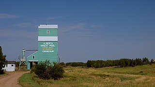
Our seventeenth stop was Kirriemuir Alberta. This is in great shape and a bit hidden way. I remember trying to decipher my own instructions to myself and was getting a bit confused. Then I realized that I haven't really seen any street signs. They do officially have street names, but I don't recall seeing any obvious signs. Those open doors do look inviting, but I decided not to venture past this point and keep a respectful distance. After Kirriemuir, our eighteenth stop would be at Esther Alberta and is covered as part of my Project365 for August 25, 2013. This is probably the most remote location on this journey. There's a sign at the highway entrance saying no gas for the next 70km. The closest hamlet to Esther is probably New Brigden and the sign for that turn off says No Services. |
| Date | Taken on 25 August 2013, 13:53 |
| Source | Kirriemuir Alberta Grain Elevator |
| Author | Wilson Hui from Calgary, Canada |
| Camera location | | View this and other nearby images on: OpenStreetMap |
|---|
.jpg¶ms=051.925425_N_-110.307476_E_globe:Earth_type:camera_source:Flickr_&language=en)
Licensing
This file is licensed under the Creative Commons Attribution 2.0 Generic license.
- You are free:
- to share – to copy, distribute and transmit the work
- to remix – to adapt the work
- Under the following conditions:
- attribution – You must give appropriate credit, provide a link to the license, and indicate if changes were made. You may do so in any reasonable manner, but not in any way that suggests the licensor endorses you or your use.
| This image was originally posted to Flickr by Wilson Hui at https://flickr.com/photos/51942038@N04/9627306600 (archive). It was reviewed on 28 November 2018 by FlickreviewR 2 and was confirmed to be licensed under the terms of the cc-by-2.0. |
File history
Click on a date/time to view the file as it appeared at that time.
| Date/Time | Thumbnail | Dimensions | User | Comment | |
|---|---|---|---|---|---|
| current | 19:18, 28 November 2018 | | 3,492 × 1,964 (1.54 MB) | Mindmatrix | Transferred from Flickr via #flickr2commons |
File usage
The following pages on the English Wikipedia use this file (pages on other projects are not listed):
.jpg)