
File:Kuckucksbähnel Strecke.png

Size of this preview: 800 × 355 pixels. Other resolutions: 320 × 142 pixels | 640 × 284 pixels | 1,406 × 624 pixels.
Original file (1,406 × 624 pixels, file size: 447 KB, MIME type: image/png)
| This is a file from the Wikimedia Commons. Information from its description page there is shown below. Commons is a freely licensed media file repository. You can help. |
| Description |
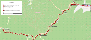
English: Map of the Kuckucksbähnel, Germany
|
| Date | |
| Source | Own work |
| Author |
Graphic made by Carport |
| Permission (Reusing this file) |
This map was created from OpenStreetMap project data, collected by the community. All OpenStreetMap data and maps are Creative Commons "CC-BY-SA 2.0" licensed This file is licensed under the Creative Commons Attribution-Share Alike 2.0 Generic license.
|
| Other versions |
|

File history
Click on a date/time to view the file as it appeared at that time.
| Date/Time | Thumbnail | Dimensions | User | Comment | |
|---|---|---|---|---|---|
| current | 15:11, 2 October 2009 | | 1,406 × 624 (447 KB) | Carport | {{Information |Description={{en|1=Map of the Kuckucksbähnel, Germany}} {{de|1=Streckenverlauf des Kuckucksbähnels von Lambrecht nach Elmstein}} |Source={{own} |
File usage
The following pages on the English Wikipedia use this file (pages on other projects are not listed):
Global file usage
The following other wikis use this file:
- Usage on de.wikipedia.org
- Usage on www.wikidata.org