
File:Ladrillo de Gudea (M.A.N. 1973-58-PO-1) 01.jpg

Size of this preview: 538 × 600 pixels. Other resolutions: 215 × 240 pixels | 431 × 480 pixels | 993 × 1,107 pixels.
Original file (993 × 1,107 pixels, file size: 169 KB, MIME type: image/jpeg)
| This is a file from the Wikimedia Commons. Information from its description page there is shown below. Commons is a freely licensed media file repository. You can help. |
| Description |
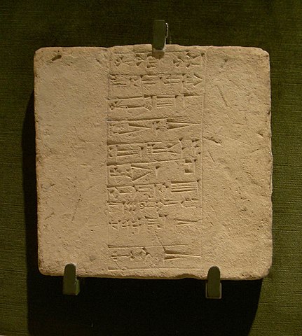
English: Tablet with cuneiform writing from the time of king Gudea of Lagash. Inscription reports on the building of a temple to god Ningirsu.
Español: Ladrillo con escritura cuneiforme de la época del rey Gudea de Lagash. La inscripción da cuenta de la edificación de un templo al dios Ningirsu. |
|||||||||||||||||||||||
| Date | between 2150 and 2100 BC | |||||||||||||||||||||||
| Medium | clay | |||||||||||||||||||||||
| Dimensions | height: 30.5 cm (12 in); width: 30.5 cm (12 in); depth: 6 cm (2.3 in) | |||||||||||||||||||||||
| Collection |
|
|||||||||||||||||||||||
| Accession number |
1973/58/PO/1 |
|||||||||||||||||||||||
| Object history |
Place of discovery: Girsu. |
|||||||||||||||||||||||
| References | Museum's website – Web del museo – Site du musée | |||||||||||||||||||||||
| Source/Photographer | Flickr. Author: Larry Wentzel, 22 May 2007. | |||||||||||||||||||||||
| Permission (Reusing this file) |
This file is licensed under the Creative Commons Attribution 2.0 Generic license.
|
|||||||||||||||||||||||

_01.jpg)
| Camera location | | View this and other nearby images on: OpenStreetMap |
|---|
_01.jpg¶ms=040.423487_N_-003.689057_E_globe:Earth_type:camera__&language=en)
File history
Click on a date/time to view the file as it appeared at that time.
| Date/Time | Thumbnail | Dimensions | User | Comment | |
|---|---|---|---|---|---|
| current | 06:14, 21 January 2011 | | 993 × 1,107 (169 KB) | Zaqarbal | Source: Flickr [http://www.flickr.com/photos/wentzelepsy/4895412484/]. Licensing: Cc-by-2.0. Author: Larry Wentzel. Taken: 22–May–2007. |
File usage
The following pages on the English Wikipedia use this file (pages on other projects are not listed):
Global file usage
The following other wikis use this file:
- Usage on el.wikipedia.org
- Usage on fr.wikipedia.org
- Usage on pl.wikipedia.org
_01.jpg)