
File:Larsen Islands - South Orkney Islands, BAT.svg

Size of this PNG preview of this SVG file: 510 × 261 pixels. Other resolutions: 320 × 164 pixels | 640 × 328 pixels | 1,024 × 524 pixels | 1,280 × 655 pixels | 2,560 × 1,310 pixels.
Original file (SVG file, nominally 510 × 261 pixels, file size: 84 KB)
| This is a file from the Wikimedia Commons. Information from its description page there is shown below. Commons is a freely licensed media file repository. You can help. |
Summary
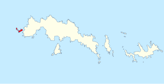
| Description | Location of the Larsen Islands in the South Orkney Islands, in the British Antarctic Territory |
| Date | |
| Source | Data from British Antarctic Survey Geodata Portal - Antarctic Digital Database |
| Author |
British Antarctic Survey
|
| Permission (Reusing this file) |
This file is licensed under the Creative Commons Attribution 4.0 International license. Attribution: Antarctic Digital Database
|
File history
Click on a date/time to view the file as it appeared at that time.
| Date/Time | Thumbnail | Dimensions | User | Comment | |
|---|---|---|---|---|---|
| current | 15:16, 26 December 2023 | | 510 × 261 (84 KB) | Hogweard | == {{int:filedesc}} == {{Information |description=Location of the Larsen Islands in the South Orkney Islands, in the British Antarctic Territory |date=2023-12-26 |source={{BAS data|source}} |author={{BAS data|author}} *Derivative work: {{u|Hogweard}} |permission={{BAS data}} |other versions= }} Category:Maps of the South Orkney Islands |
File usage
The following pages on the English Wikipedia use this file (pages on other projects are not listed):