
File:Lauttasaari district topo map-fr.svg

Size of this PNG preview of this SVG file: 491 × 600 pixels. Other resolutions: 196 × 240 pixels | 393 × 480 pixels | 628 × 768 pixels | 838 × 1,024 pixels | 1,676 × 2,048 pixels | 856 × 1,046 pixels.
Original file (SVG file, nominally 856 × 1,046 pixels, file size: 239 KB)
| This is a file from the Wikimedia Commons. Information from its description page there is shown below. Commons is a freely licensed media file repository. You can help. |
| Description |
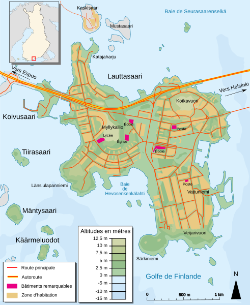
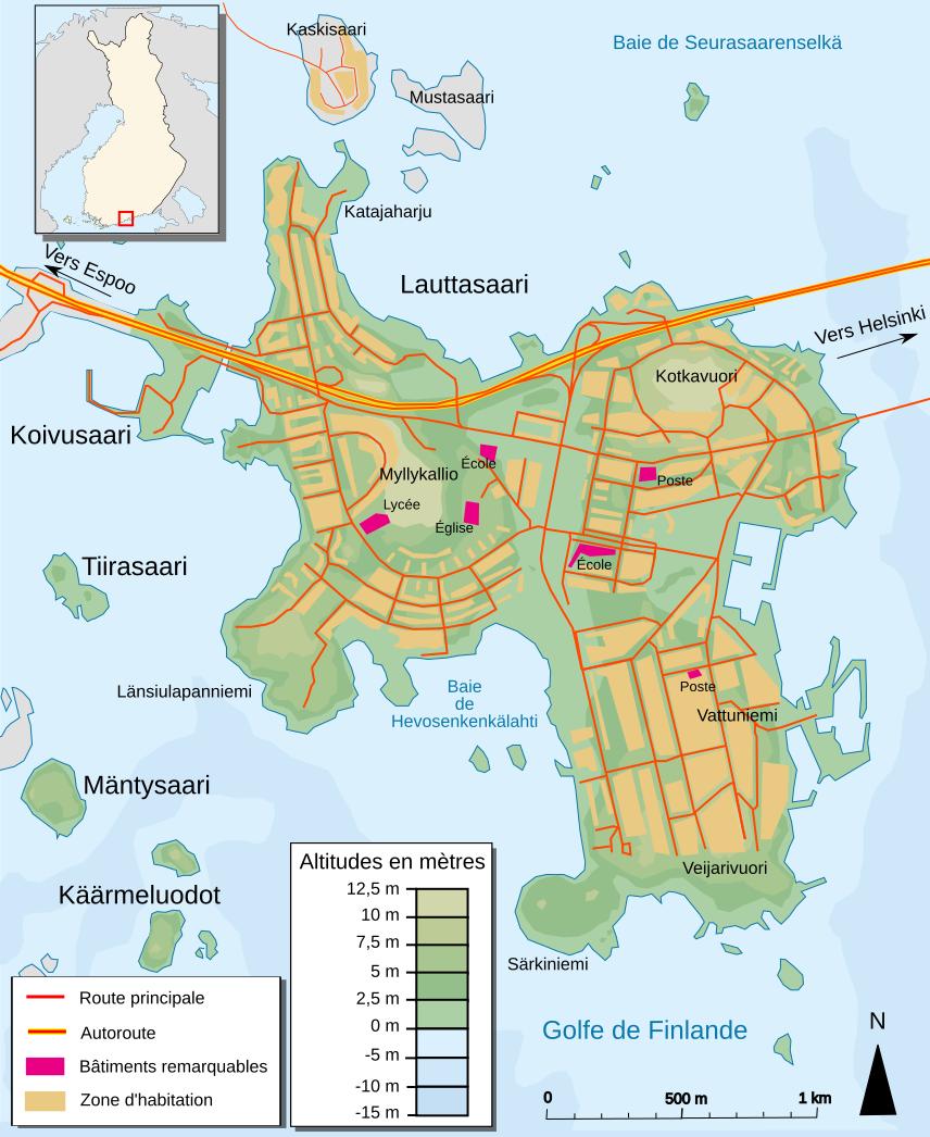
Français : Carte topographique du district de Lauttasaari dans le golfe de Finlande |
| Date | |
| Source | travail personnel made with Inkscape from Image:LauttasaariMap.png for the background and map for the names and others details |
| Author | Pinpin |
| Other versions |
|


This W3C-unspecified vector image was created with Inkscape .
I, the copyright holder of this work, hereby publish it under the following licenses:

|
Permission is granted to copy, distribute and/or modify this document under the terms of the GNU Free Documentation License, Version 1.2 or any later version published by the Free Software Foundation; with no Invariant Sections, no Front-Cover Texts, and no Back-Cover Texts. A copy of the license is included in the section entitled GNU Free Documentation License. |
This file is licensed under the Creative Commons Attribution-Share Alike 3.0 Unported, 2.5 Generic, 2.0 Generic and 1.0 Generic license.
- You are free:
- to share – to copy, distribute and transmit the work
- to remix – to adapt the work
- Under the following conditions:
- attribution – You must give appropriate credit, provide a link to the license, and indicate if changes were made. You may do so in any reasonable manner, but not in any way that suggests the licensor endorses you or your use.
- share alike – If you remix, transform, or build upon the material, you must distribute your contributions under the same or compatible license as the original.
You may select the license of your choice.
File history
Click on a date/time to view the file as it appeared at that time.
| Date/Time | Thumbnail | Dimensions | User | Comment | |
|---|---|---|---|---|---|
| current | 22:34, 4 October 2007 | | 856 × 1,046 (239 KB) | Pinpin | |
| 17:36, 4 October 2007 |  | 856 × 1,046 (239 KB) | Pinpin | change situation map | |
| 17:33, 4 October 2007 |  | 856 × 1,046 (243 KB) | Pinpin | add text | |
| 19:12, 3 October 2007 |  | 856 × 1,046 (233 KB) | Pinpin | better arrows | |
| 19:09, 3 October 2007 |  | 856 × 1,046 (233 KB) | Pinpin | ||
| 19:07, 3 October 2007 |  | 856 × 1,046 (233 KB) | Pinpin | little details | |
| 17:38, 3 October 2007 |  | 856 × 1,046 (232 KB) | Pinpin | fini ? | |
| 19:58, 2 October 2007 |  | 855 × 1,049 (119 KB) | Pinpin | ||
| 19:35, 2 October 2007 |  | 855 × 1,049 (122 KB) | Pinpin | {{Information |Description={{fr}} Carte topographique du district de Lauttasaari dans le golfe de Finlande |Source=travail personnel made with Inkscape from [http://kansalaisen.karttapaikka.fi/kartanhaku/koordinaattihaku.html?cx=2548708&cy=6672017&scale=4 |
File usage
The following pages on the English Wikipedia use this file (pages on other projects are not listed):
Global file usage
The following other wikis use this file:
- Usage on ca.wikipedia.org
- Usage on es.wikipedia.org
- Usage on fa.wikipedia.org
- Usage on fr.wikipedia.org
- Usage on nl.wikipedia.org
- Usage on pl.wikipedia.org
- Usage on ru.wikipedia.org
- Usage on tr.wikipedia.org
- Usage on zh.wikipedia.org