
File:Liverpool Plains Aquifers.png
No higher resolution available.
Liverpool_Plains_Aquifers.png (425 × 234 pixels, file size: 28 KB, MIME type: image/png)
Summary[edit]
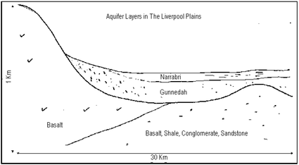
| Description | Schematic drawing of the Liverpool Plains aquifers. |
|---|---|
| Author or copyright owner |
CSIRO |
| Source (WP:NFCC#4) | CSIRO |
| Date of publication | 1997 |
| Use in article (WP:NFCC#7) | Somerton, New South Wales |
| Purpose of use in article (WP:NFCC#8) | To support encyclopedic discussion of this work in this article. The illustration is specifically needed to support the following point(s): The technical placement of the Narrabri/Gunnedah formations. |
| Not replaceable with free media because (WP:NFCC#1) |
n.a. |
| Minimal use (WP:NFCC#3) | Provides technical context for article. |
| Respect for commercial opportunities (WP:NFCC#2) |
n.a. |
| Other information | https://publications.csiro.au/rpr/pub?list=BRO&pid=procite:a75e3077-6b31-44c3-9943-1bcbbc6cb208 |
| Fair useFair use of copyrighted material in the context of Somerton, New South Wales//en.wikipedia.org/wiki/File:Liverpool_Plains_Aquifers.pngtrue | |
Licensing[edit]
 | This work is copyrighted (or assumed to be copyrighted) and unlicensed. It does not fall into one of the blanket acceptable non-free content categories listed at Wikipedia:Non-free content § Images or Wikipedia:Non-free content § Audio clips, and it is not covered by a more specific non-free content license listed at Category:Wikipedia non-free file copyright templates. However, it is believed that the use of this work:
qualifies as fair use under United States copyright law. Any other uses of this image, on Wikipedia or elsewhere, may be copyright infringement. See Wikipedia:Non-free content and Wikipedia:Copyrights. | ||
| |||
File history
Click on a date/time to view the file as it appeared at that time.
| Date/Time | Thumbnail | Dimensions | User | Comment | |
|---|---|---|---|---|---|
| current | 07:34, 13 February 2017 | | 425 × 234 (28 KB) | DatBot (talk | contribs) | Reduce size of non-free image (BOT - disable) |
| 22:23, 24 March 2016 | No thumbnail | 963 × 531 (35 KB) | VillageInterest (talk | contribs) | Uploading a non-free work, as object of commentary using File Upload Wizard |
You cannot overwrite this file.
File usage
The following pages on the English Wikipedia use this file (pages on other projects are not listed):