
File:Location of the province Tarata in Tacna.svg

Size of this PNG preview of this SVG file: 456 × 599 pixels. Other resolutions: 182 × 240 pixels | 365 × 480 pixels | 584 × 768 pixels | 779 × 1,024 pixels | 1,558 × 2,048 pixels | 490 × 644 pixels.
Original file (SVG file, nominally 490 × 644 pixels, file size: 324 KB)
| This is a file from the Wikimedia Commons. Information from its description page there is shown below. Commons is a freely licensed media file repository. You can help. |
Summary
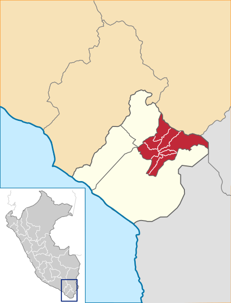
| Description | Location of the province Tarata in the Tacna region in Peru (Map) |
| Date | |
| Source | Own work |
| Author | AgainErick |
| Permission (Reusing this file) |
GFDL |
Licensing
I, the copyright holder of this work, hereby publish it under the following licenses:

|
Permission is granted to copy, distribute and/or modify this document under the terms of the GNU Free Documentation License, Version 1.2 or any later version published by the Free Software Foundation; with no Invariant Sections, no Front-Cover Texts, and no Back-Cover Texts. A copy of the license is included in the section entitled GNU Free Documentation License. |
| This file is licensed under the Creative Commons Attribution-Share Alike 3.0 Unported license. | ||
| ||
| This licensing tag was added to this file as part of the GFDL licensing update. |
This file is licensed under the Creative Commons Attribution-Share Alike 2.5 Generic, 2.0 Generic and 1.0 Generic license.
- You are free:
- to share – to copy, distribute and transmit the work
- to remix – to adapt the work
- Under the following conditions:
- attribution – You must give appropriate credit, provide a link to the license, and indicate if changes were made. You may do so in any reasonable manner, but not in any way that suggests the licensor endorses you or your use.
- share alike – If you remix, transform, or build upon the material, you must distribute your contributions under the same or compatible license as the original.
You may select the license of your choice.
File history
Click on a date/time to view the file as it appeared at that time.
| Date/Time | Thumbnail | Dimensions | User | Comment | |
|---|---|---|---|---|---|
| current | 17:31, 22 July 2018 | | 490 × 644 (324 KB) | Janitoalevic | Fixed coastline |
| 01:47, 18 April 2016 |  | 490 × 644 (354 KB) | Janitoalevic | Better borders and coastline, new colors. | |
| 22:17, 22 August 2007 |  | 490 × 644 (361 KB) | AgainErick | Replaced with new version including the Peru mini-map. | |
| 19:35, 19 April 2007 |  | 304 × 293 (27 KB) | AgainErick | {{Information |Description=Location of the province Tarata in the Tacna region in Peru (Map) |Source=own work |Date=april 19 2007 |Author=Eric Bronder |Permission=GFDL |other_versions= }} Tacna |
File usage
The following pages on the English Wikipedia use this file (pages on other projects are not listed):
Global file usage
The following other wikis use this file:
- Usage on ay.wikipedia.org
- Usage on de.wikipedia.org
- Usage on es.wikipedia.org
- Usage on fa.wikipedia.org
- Usage on fr.wikipedia.org
- Usage on ia.wikipedia.org
- Usage on it.wikipedia.org
- Usage on ka.wikipedia.org
- Usage on nl.wikipedia.org
- Usage on pt.wikipedia.org
- Usage on qu.wikipedia.org
- Usage on ro.wikipedia.org
- Usage on ru.wikipedia.org
- Usage on uk.wikipedia.org
- Usage on vi.wikipedia.org
- Usage on www.wikidata.org
- Usage on xmf.wikipedia.org
- Usage on zh-min-nan.wikipedia.org