
File:Losail.svg

Size of this PNG preview of this SVG file: 800 × 595 pixels. Other resolutions: 320 × 238 pixels | 640 × 476 pixels | 1,024 × 761 pixels | 1,280 × 952 pixels | 2,560 × 1,903 pixels | 1,201 × 893 pixels.
Original file (SVG file, nominally 1,201 × 893 pixels, file size: 41 KB)
| This is a file from the Wikimedia Commons. Information from its description page there is shown below. Commons is a freely licensed media file repository. You can help. |
Summary
| Description | |
| Date | 8-3-2008 |
| Source | Own work |
| Author | Will Pittenger |
| Other versions |
|

| Camera location | | View this and other nearby images on: OpenStreetMap |
|---|
Licensing
I, the copyright holder of this work, hereby publish it under the following license:
This file is licensed under the Creative Commons Attribution-Share Alike 3.0 Unported license.
- You are free:
- to share – to copy, distribute and transmit the work
- to remix – to adapt the work
- Under the following conditions:
- attribution – You must give appropriate credit, provide a link to the license, and indicate if changes were made. You may do so in any reasonable manner, but not in any way that suggests the licensor endorses you or your use.
- share alike – If you remix, transform, or build upon the material, you must distribute your contributions under the same or compatible license as the original.
File history
Click on a date/time to view the file as it appeared at that time.
| Date/Time | Thumbnail | Dimensions | User | Comment | |
|---|---|---|---|---|---|
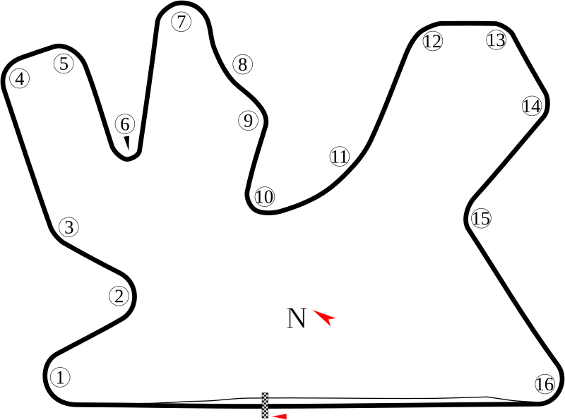
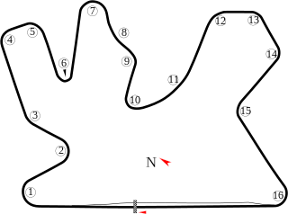
| current | 11:40, 3 August 2008 | | 1,201 × 893 (41 KB) | Will Pittenger | {{Information |Description={{en|1=Track map of w:Losail International Circuit in w:Qatar.}} |Source=Own work by uploader |Author=Will Pittenger |Date=8-3-2008 |Permission= |other_versions=<gallery>Image:Losail Internationa |
File usage
The following pages on the English Wikipedia use this file (pages on other projects are not listed):
- 2004 Qatar motorcycle Grand Prix
- 2005 Losail Superbike World Championship round
- 2005 Qatar motorcycle Grand Prix
- 2006 Losail Superbike World Championship round
- 2006 Qatar motorcycle Grand Prix
- 2007 Losail Superbike World Championship round
- 2007 Qatar motorcycle Grand Prix
- 2008 Losail Superbike World Championship round
- 2008 Qatar motorcycle Grand Prix
- 2009 Losail Superbike World Championship round
- 2009 Qatar GP2 Asia Series round
- 2009 Qatar Speedcar Series round
- 2009 Qatar motorcycle Grand Prix
- 2010 Qatar motorcycle Grand Prix
- 2011 Qatar motorcycle Grand Prix
- 2012 Qatar motorcycle Grand Prix
- 2013 Qatar motorcycle Grand Prix
- 2014 Qatar motorcycle Grand Prix
- 2015 Qatar motorcycle Grand Prix
- 2016 Losail Superbike World Championship round
- 2016 Qatar motorcycle Grand Prix
- 2017 Qatar motorcycle Grand Prix
- 2018 Qatar motorcycle Grand Prix
- 2019 Qatar motorcycle Grand Prix
- 2020 Qatar motorcycle Grand Prix
- 2021 Doha motorcycle Grand Prix
- 2021 Qatar Grand Prix
- 2021 Qatar motorcycle Grand Prix
- 2022 Qatar motorcycle Grand Prix
- 2024 Qatar motorcycle Grand Prix
- FIA WTCC Race of Qatar
- List of FIA World Touring Car Championship circuits
- List of Superbike World Championship circuits
- Lusail International Circuit
- User:SSSB/sandbox/1
- Template talk:Infobox Grand Prix race report
Global file usage
The following other wikis use this file:
- Usage on af.wikipedia.org
- Usage on ar.wikipedia.org
- جائزة قطر الكبرى للدراجات النارية 2006
- جائزة قطر الكبرى للدراجات النارية 2007
- جائزة قطر الكبرى للدراجات النارية 2008
- جائزة قطر الكبرى للدراجات النارية 2009
- جائزة قطر الكبرى للدراجات النارية 2011
- جائزة قطر الكبرى للدراجات النارية 2012
- جائزة قطر الكبرى للدراجات النارية 2013
- جائزة قطر الكبرى للدراجات النارية 2014
- جائزة قطر الكبرى للدراجات النارية 2015
- جائزة قطر الكبرى للدراجات النارية 2004
- جائزة قطر الكبرى للدراجات النارية 2005
- جائزة قطر الكبرى للدراجات النارية 2010
- جائزة قطر الكبرى للدراجات النارية 2018
- جائزة قطر الكبرى للدراجات النارية 2019
- جائزة قطر الكبرى
- جائزة قطر الكبرى 2021
- Usage on ca.wikipedia.org
- Gran Premi de Qatar de motociclisme de 2009
- Gran Premi de Qatar de motociclisme
- Gran Premi de Qatar de motociclisme de 2013
- Gran Premi de Qatar de motociclisme de 2012
- Gran Premi de Qatar de motociclisme de 2011
- Gran Premi de Qatar de motociclisme de 2010
- Gran Premi de Qatar de motociclisme de 2014
- Gran Premi de Qatar de motociclisme de 2018
- Gran Premi de Qatar de motociclisme de 2019
- Temporada 2021 de Fórmula 1
- Gran Premi de Doha de motociclisme de 2021
- Gran Premi de Qatar de motociclisme de 2021
- Gran Premi de Qatar de motociclisme de 2006
- Temporada 2023 de Fórmula 1
- Usage on cs.wikipedia.org
- Usage on de.wikipedia.org
- Liste der Formel-1-Rennstrecken
- Motorrad-Weltmeisterschaft 2013
- Diskussion:Motorrad-Weltmeisterschaft 2013
- Motorrad-Weltmeisterschaft 2014
- Motorrad-Weltmeisterschaft 2015
- Benutzer:Saber-rider1/Vorbereitungen
- Benutzer:Saber-rider1/Vorbereitungen2
- Motorrad-Weltmeisterschaft 2016
- Superbike-Weltmeisterschaft 2016
- Supersport-Weltmeisterschaft 2016
- Motorrad-Weltmeisterschaft 2017
- Superbike-Weltmeisterschaft 2017
- Supersport-Weltmeisterschaft 2017
View more global usage of this file.