
File:MBTA Green Line.svg

Size of this PNG preview of this SVG file: 657 × 600 pixels. Other resolutions: 263 × 240 pixels | 526 × 480 pixels | 841 × 768 pixels | 1,122 × 1,024 pixels | 2,243 × 2,048 pixels | 1,150 × 1,050 pixels.
Original file (SVG file, nominally 1,150 × 1,050 pixels, file size: 61 KB)
| This is a file from the Wikimedia Commons. Information from its description page there is shown below. Commons is a freely licensed media file repository. You can help. |
Summary
| Description |
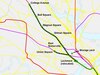
English: Schematic map of MBTA Green Line branches and stops, including abandoned Watertown (A) and Extension (under construction). Station names sourced from Wikipedia articles and 2014 Blue Book. |
| Date | |
| Source | Own work |
| Author | Mliu92 |
| Other versions |
This file was derived from: |


Licensing
I, the copyright holder of this work, hereby publish it under the following license:
This file is licensed under the Creative Commons Attribution-Share Alike 4.0 International license.
- You are free:
- to share – to copy, distribute and transmit the work
- to remix – to adapt the work
- Under the following conditions:
- attribution – You must give appropriate credit, provide a link to the license, and indicate if changes were made. You may do so in any reasonable manner, but not in any way that suggests the licensor endorses you or your use.
- share alike – If you remix, transform, or build upon the material, you must distribute your contributions under the same or compatible license as the original.
File history
Click on a date/time to view the file as it appeared at that time.
| Date/Time | Thumbnail | Dimensions | User | Comment | |
|---|---|---|---|---|---|
| current | 18:02, 12 December 2022 | | 1,150 × 1,050 (61 KB) | Pi.1415926535 | update for GLX opening |
| 17:57, 19 March 2022 |  | 1,150 × 1,050 (32 KB) | Mliu92 | Updates to E branch & opening of Union Square branch past Lechmere. | |
| 16:44, 27 September 2021 |  | 1,150 × 1,050 (42 KB) | Mliu92 | Updated name: College Ave -> Medford/Tufts | |
| 17:45, 2 January 2019 |  | 1,150 × 1,050 (42 KB) | Mliu92 | Switched lables for St Paul St / Babcock St. | |
| 15:58, 28 December 2018 |  | 1,150 × 1,050 (42 KB) | Mliu92 | Removed hidden layer, improved text display (buggy overuse of bold). | |
| 15:50, 28 December 2018 |  | 1,150 × 1,050 (218 KB) | Mliu92 | User created page with UploadWizard |
File usage
The following pages on the English Wikipedia use this file (pages on other projects are not listed):
Global file usage
The following other wikis use this file:
- Usage on de.wikipedia.org
- Usage on it.wikipedia.org
- Usage on nl.wikipedia.org
- Usage on ru.wikipedia.org
- Usage on www.wikidata.org
- Usage on zh.wikipedia.org