
File:Map-Northern Patagonia-Argentina-political.png

Size of this preview: 800 × 563 pixels. Other resolutions: 320 × 225 pixels | 640 × 450 pixels | 1,024 × 721 pixels | 1,280 × 901 pixels | 1,731 × 1,218 pixels.
Original file (1,731 × 1,218 pixels, file size: 663 KB, MIME type: image/png)
| This is a file from the Wikimedia Commons. Information from its description page there is shown below. Commons is a freely licensed media file repository. You can help. |
Summary
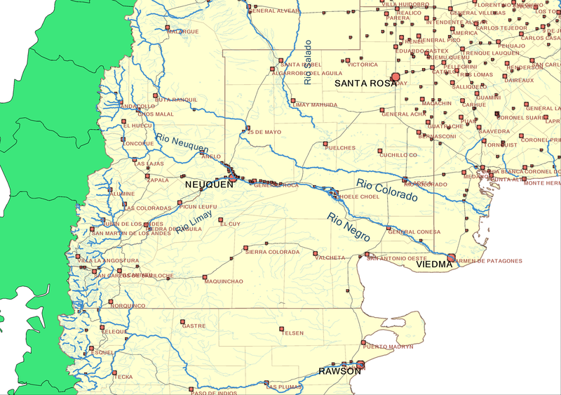
Map of Northern Patagonia, Argentina. Includes main rivers, provincial and departamental divisions, provincial capitals and heads of departments with names, and national routes (not labeled).
Created by me on September 2006. Mariano 13:05, 8 September 2006 (UTC)
Disclosure
 Map created with a number of tools including Quantum GIS, WinChips[1], and Inkscape, from data information obtained at the sources listed below.
 Mapa realizado con varias herramientas, incluidos Quantum GIS, WinChips[2], e Inkscape, en base a los datos de dominio publico, entre los cuales pueden estar las fuentes abajo citadas.
- Souces/Fuentes
- National Geophysical Data Center[3]
- Digital Map of the World Server[4]
- National Geospacial-intelligence Agency[5]
- JPL world map service[6] (via WMS)
- United Nations Environment Programme[7]
- Earth Resources Observation and Science (EROS)[8]
- USGS HydroSHEDS[9]
- Global Lakes and Wetlands Database GLWD[10]
- AeroTerra[11]
- Global Rural-Urban Mapping Project (GRUMP)[12]
- [Lehner, B. and P. Döll (2004): Development and validation of a global database of lakes, reservoirs and wetlands. Journal of Hydrology 296/1-4: 1-22.]
- Terrestrial Ecoregions GIS Database[13]
- [Olson, D. M. and E. Dinerstein. The Global 200: Priority ecoregions for global conservation. (PDF file) Annals of the Missouri Botanical Garden 89:125-126.]
Licensing
I, the copyright holder of this work, hereby publish it under the following licenses:

|
Permission is granted to copy, distribute and/or modify this document under the terms of the GNU Free Documentation License, Version 1.2 or any later version published by the Free Software Foundation; with no Invariant Sections, no Front-Cover Texts, and no Back-Cover Texts. A copy of the license is included in the section entitled GNU Free Documentation License. |
| This file is licensed under the Creative Commons Attribution-Share Alike 3.0 Unported license. | ||
| ||
| This licensing tag was added to this file as part of the GFDL licensing update. |
This file is licensed under the Creative Commons Attribution-Share Alike 2.5 Generic, 2.0 Generic and 1.0 Generic license.
- You are free:
- to share – to copy, distribute and transmit the work
- to remix – to adapt the work
- Under the following conditions:
- attribution – You must give appropriate credit, provide a link to the license, and indicate if changes were made. You may do so in any reasonable manner, but not in any way that suggests the licensor endorses you or your use.
- share alike – If you remix, transform, or build upon the material, you must distribute your contributions under the same or compatible license as the original.
You may select the license of your choice.
File history
Click on a date/time to view the file as it appeared at that time.
| Date/Time | Thumbnail | Dimensions | User | Comment | |
|---|---|---|---|---|---|
| current | 18:58, 22 December 2017 | | 1,731 × 1,218 (663 KB) | Janitoalevic | Fixed borders. |
| 13:05, 8 September 2006 |  | 1,731 × 1,218 (456 KB) | Marianocecowski | Map of Northern Patagonia, Argentina. Includes main rivers, provincial and departamental divisions, provincial capitals and heads of departments with names, and national routes (not labeled). Created by me on September 2006. ~~~~ {{User:Marianocecowski/ |
File usage
The following pages on the English Wikipedia use this file (pages on other projects are not listed):
Global file usage
The following other wikis use this file:
- Usage on br.wikipedia.org
- Usage on cs.wikipedia.org
- Usage on de.wikipedia.org
- Usage on el.wikipedia.org
- Usage on eo.wikipedia.org
- Usage on es.wikipedia.org
- Usage on fr.wikipedia.org
- Usage on gl.wikipedia.org
- Usage on he.wikipedia.org
- Usage on hr.wikipedia.org
- Usage on hu.wikipedia.org
- Usage on it.wikipedia.org
- Usage on ja.wikipedia.org
- Usage on ka.wikipedia.org
- Usage on no.wikipedia.org
- Usage on sco.wikipedia.org
- Usage on sh.wikipedia.org
- Usage on uk.wikipedia.org
- Usage on www.wikidata.org