
File:Metro de Santiago (futuro).svg

Size of this PNG preview of this SVG file: 500 × 600 pixels. Other resolutions: 200 × 240 pixels | 400 × 480 pixels | 640 × 768 pixels | 853 × 1,024 pixels | 1,707 × 2,048 pixels | 1,500 × 1,800 pixels.
Original file (SVG file, nominally 1,500 × 1,800 pixels, file size: 1.25 MB)
| This is a file from the Wikimedia Commons. Information from its description page there is shown below. Commons is a freely licensed media file repository. You can help. |
Summary
| Description |
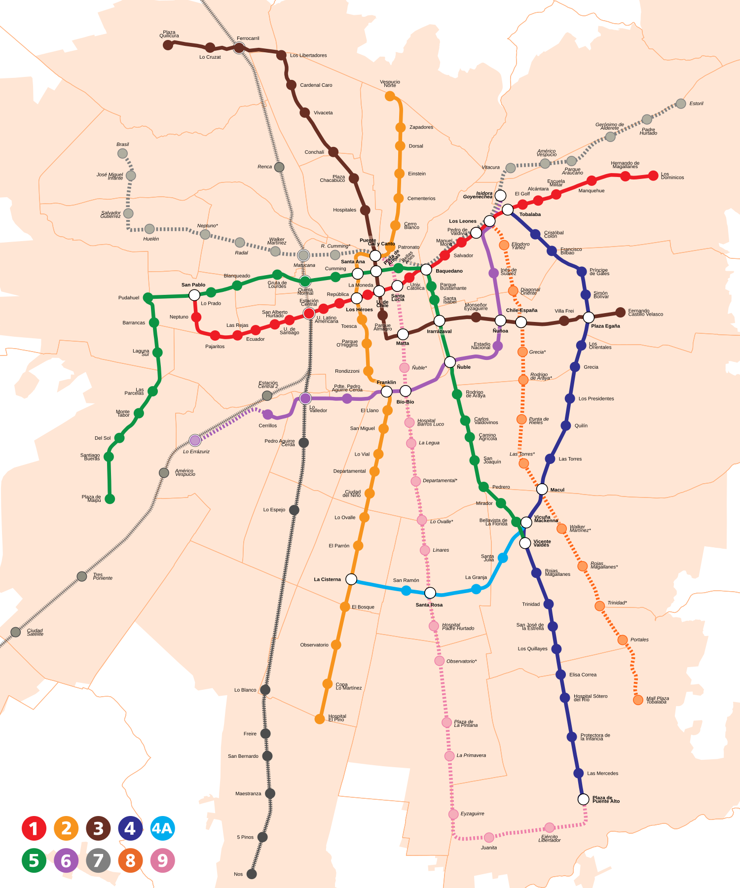
Español: Mapa de líneas y estaciones del Metro de Santiago, Chile hacia 2026. El mapa está a escala. Incluye servicios de tren de cercanías Metrotren.
La información sobre las líneas y estaciones propuestas es referencial y está sujeta a modificaciones. English: Map of expected lines and stations for 2026 in the subway of Santiago, Chile (to scale). It includes the Metrotren suburban railway.
Information regarding proposed lines is only referential and is subject to changes. |
| Date | |
| Source | |
| Author | B1mbo |
| Permission (Reusing this file) |
I, the copyright holder of this work, hereby publish it under the following license: This file is licensed under the Creative Commons Attribution-Share Alike 4.0 International license.
|
| Other versions |
 |

.svg)
.svg)
.svg)


.svg)
File history
Click on a date/time to view the file as it appeared at that time.
| Date/Time | Thumbnail | Dimensions | User | Comment | |
|---|---|---|---|---|---|
| current | 04:48, 28 November 2023 | | 1,500 × 1,800 (1.25 MB) | B1mbo | + L2 a San Bernardo |
| 23:54, 25 September 2023 |  | 1,500 × 1,800 (1.25 MB) | B1mbo | L3 Quilicura inaugurada | |
| 02:26, 10 August 2023 |  | 1,500 × 1,800 (1.25 MB) | B1mbo | Actualización trayecto Línea 9 | |
| 06:08, 13 April 2023 |  | 1,500 × 1,800 (1.25 MB) | B1mbo | Corrección de nombres estaciones futuras | |
| 00:57, 24 July 2019 |  | 1,500 × 1,800 (1.25 MB) | B1mbo | +L9 stations | |
| 05:06, 21 July 2019 |  | 1,500 × 1,800 (1.24 MB) | B1mbo | correciones L4E y L9 | |
| 05:57, 19 July 2019 |  | 1,500 × 1,800 (1.24 MB) | B1mbo | Estaciones L8 | |
| 06:58, 11 August 2018 |  | 1,500 × 1,800 (1.2 MB) | B1mbo | minor corrections | |
| 05:44, 9 July 2018 |  | 1,500 × 1,800 (1.21 MB) | B1mbo | == {{int:filedesc}} == {{Information |Description={{es|Mapa de líneas y estaciones del Metro de Santiago, Chile. El mapa está a escala.}}{{en|Map of subway of Santiago, Chile (to scale).}} |Source=*{{own}} *[http://www.ine.cl/herramientas/galeria-de-mapas/metodolog%C3%ADa-para-medir-el-crecimiento-urbano-de-las-ciudades-de-chile Mapa de Área urbana consolidada de Santiago (INE, 2016)] *Logos: [[:Image:Sa... |
File usage
The following pages on the English Wikipedia use this file (pages on other projects are not listed):
Global file usage
The following other wikis use this file:
- Usage on de.wikipedia.org
- Usage on es.wikipedia.org
- Usage on he.wikipedia.org
- Usage on ru.wikipedia.org
.svg)