
File:Miners Needle from Bluff Spring Trail, Superstition Wilderness.jpg

Original file (3,648 × 2,736 pixels, file size: 2.3 MB, MIME type: image/jpeg)
| This is a file from the Wikimedia Commons. Information from its description page there is shown below. Commons is a freely licensed media file repository. You can help. |
Summary
| Description |
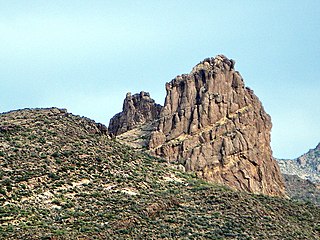
English: This is the view looking northeast at Miner's Needle from the Bluff Spring Trail. This area figures prominently in the legends of gold in the Supes. The Lost Dutchman's Mine is thought to be near here.
I hiked the Charleyboy Duece Loop - the hike shown as Charlebois Loop II in "Hiker's Guide to the Superstition Wilderness" by Jack Stewart and Liz Carlson. From Wikipedia: "The Superstition Mountains, popularly referred to as "The Superstitions" or "The Supes", are a range of mountains in Arizona located to the east of the Phoenix metropolitan area. They are anchored by Superstition Mountain, a large mountain that is a popular recreation destination for residents of the Phoenix, Arizona area. The mountain range is in the federally-designated Superstition Wilderness Area, and includes a variety of natural features in addition to the mountain that is its namesake. Weaver's Needle, a prominent landmark and rock climbing destination set behind and to the east of Superstition Mountain, is a tall erosional remnant [1] that plays a significant role in the legend of the Lost Dutchman's Gold Mine. Peralta Canyon, on the northeast side of Superstition Mountain, contains a popular trail that leads up to Freemont Saddle, which provides a very picturesque view of Weaver's Needle. Miner's Needle is another prominent formation in the wilderness and a popular hiking destination." |
| Date | |
| Source |
Miner's Needle from Bluff Spring Trail - Superstition Wilderness
|
| Author | Alan English CPA from Scottsdale, Arizona 85254, USA |
| Camera location | | View this and other nearby images on: OpenStreetMap |
|---|
Licensing
- You are free:
- to share – to copy, distribute and transmit the work
- to remix – to adapt the work
- Under the following conditions:
- attribution – You must give appropriate credit, provide a link to the license, and indicate if changes were made. You may do so in any reasonable manner, but not in any way that suggests the licensor endorses you or your use.
- share alike – If you remix, transform, or build upon the material, you must distribute your contributions under the same or compatible license as the original.
| This image, originally posted to Flickr, was reviewed on February 19, 2011 by the administrator or reviewer File Upload Bot (Magnus Manske), who confirmed that it was available on Flickr under the stated license on that date. |
File history
Click on a date/time to view the file as it appeared at that time.
| Date/Time | Thumbnail | Dimensions | User | Comment | |
|---|---|---|---|---|---|
| current | 23:06, 19 February 2011 | | 3,648 × 2,736 (2.3 MB) | File Upload Bot (Magnus Manske) | {{Information |Description=This is the view looking northeast at Miner's Needle from the Bluff Spring Trail. This area figures prominently in the legends of gold in the Supes. The Lost Dutchman's Mine is thought to be near here. I hiked the Charleyboy |
File usage
Global file usage
The following other wikis use this file:
- Usage on de.wikipedia.org
- Usage on ja.wikipedia.org
- Usage on nl.wikipedia.org
- Usage on pl.wikipedia.org
- Usage on www.wikidata.org