
File:Morocco, Drâa-Tafilalet Region, Tinghir Province, Boumalne-Dadès (2).jpg

Size of this preview: 800 × 531 pixels. Other resolutions: 320 × 213 pixels | 640 × 425 pixels | 1,024 × 680 pixels | 1,280 × 850 pixels | 2,144 × 1,424 pixels.
Original file (2,144 × 1,424 pixels, file size: 822 KB, MIME type: image/jpeg)
| This is a file from the Wikimedia Commons. Information from its description page there is shown below. Commons is a freely licensed media file repository. You can help. |
.jpg)
Summary
| Description |
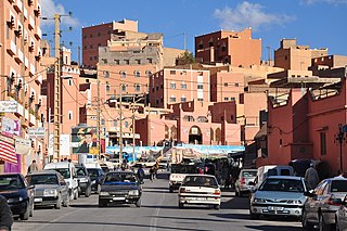
English: Main street in the centre of Boumalne-Dadès, a city in southern Morocco (Drâa-Tafilalet Region, Tinghir Province).
Nederlands: Hoofdstraat door het centrum van Boumalne-Dadès, een stad in Zuid-Marokko (Regio Drâa-Tafilalet, Provincie Tinghir). |
| Date | |
| Source | Own work |
| Author | Vincent van Zeijst |
Looking to the southeast from:
| Camera location | | View this and other nearby images on: OpenStreetMap |
|---|
.jpg¶ms=031.373156_N_-005.987097_E_globe:Earth_type:camera__&language=en)
Licensing
I, the copyright holder of this work, hereby publish it under the following licenses:
This file is licensed under the Creative Commons Attribution-Share Alike 4.0 International license.
- You are free:
- to share – to copy, distribute and transmit the work
- to remix – to adapt the work
- Under the following conditions:
- attribution – You must give appropriate credit, provide a link to the license, and indicate if changes were made. You may do so in any reasonable manner, but not in any way that suggests the licensor endorses you or your use.
- share alike – If you remix, transform, or build upon the material, you must distribute your contributions under the same or compatible license as the original.

|
Permission is granted to copy, distribute and/or modify this document under the terms of the GNU Free Documentation License, Version 1.2 or any later version published by the Free Software Foundation; with no Invariant Sections, no Front-Cover Texts, and no Back-Cover Texts. A copy of the license is included in the section entitled GNU Free Documentation License. |
You may select the license of your choice.
File history
Click on a date/time to view the file as it appeared at that time.
| Date/Time | Thumbnail | Dimensions | User | Comment | |
|---|---|---|---|---|---|
| current | 22:00, 2 April 2019 | | 2,144 × 1,424 (822 KB) | Loranchet | {{Information |description ={{en|1=Main street in the centre of Boumalne-Dadès, a city in southern Morocco (Drâa-Tafilalet Region, Tinghir Province).}} {{nl|1=Hoofdstraat door het centrum van Boumalne-Dadès, een stad in Zuid-Marokko (Regio Drâa-Tafilalet, Provincie Tinghir).}} |date =2013-04-29 |source ={{own}} |author =Vincent van Zeijst }} Looking to the southeast from: {{Location|31|22|23.36|N|5|59|13.55|W}} Category:2013 in Morocco [[Category:Street scenes in... |
File usage
The following pages on the English Wikipedia use this file (pages on other projects are not listed):
Global file usage
The following other wikis use this file:
- Usage on ary.wikipedia.org
- Usage on arz.wikipedia.org
- Usage on ca.wikipedia.org
- Usage on de.wikivoyage.org
- Usage on fr.wikipedia.org
- Usage on www.wikidata.org
.jpg)