
File:Moses Bailey house Winthrop Maine.jpg

Original file (1,972 × 944 pixels, file size: 224 KB, MIME type: image/jpeg)
| This is a file from the Wikimedia Commons. Information from its description page there is shown below. Commons is a freely licensed media file repository. You can help. |
Summary
| Description |
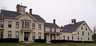
English: Moses Bailey House
English: Moses Bailey House
From Wikipedia, the free encyclopedia Jump to: navigation, search
Moses Bailey House
Moses Bailey House Moses Bailey House is located in the US Moses Bailey House Show map of Maine Show map of the US Show all
Coordinates 44°18′20″N 69°55′24″WCoordinates: 44°18′20″N 69°55′24″W Area 0.5 acres (0.20 ha) Built 1853 Architectural style Greek Revival, Italianate NRHP Reference # 84000325[1] Added to NRHP November 8, 1984 The Moses Bailey House is a historic house at 209 Winthrop Center Road in the Winthrop Center village of Winthrop, Maine. Built about 1853, with additional Italianate styling added in 1870, it is one of Winthrop's finest surviving mid 19th-century farm houses. It was listed on the National Register of Historic Places in 1984.[1] It has been divided into apartments and is known as Bailey Manor.
|
||
| Date | |||
| Source | Own work | ||
| Author | Bailey Manor |
| Camera location | | View this and other nearby images on: OpenStreetMap |
|---|
Licensing
- You are free:
- to share – to copy, distribute and transmit the work
- to remix – to adapt the work
- Under the following conditions:
- attribution – You must give appropriate credit, provide a link to the license, and indicate if changes were made. You may do so in any reasonable manner, but not in any way that suggests the licensor endorses you or your use.
- share alike – If you remix, transform, or build upon the material, you must distribute your contributions under the same or compatible license as the original.
File history
Click on a date/time to view the file as it appeared at that time.
| Date/Time | Thumbnail | Dimensions | User | Comment | |
|---|---|---|---|---|---|
| current | 01:02, 15 October 2016 | | 1,972 × 944 (224 KB) | Bailey Manor | User created page with UploadWizard |
File usage
Global file usage
The following other wikis use this file:
- Usage on de.wikipedia.org
- Usage on www.wikidata.org