
File:Nansen Franz Josef Land Voyage Map.PNG
Size of this preview: 800 × 537 pixels. Other resolutions: 320 × 215 pixels | 640 × 430 pixels | 1,017 × 683 pixels.
Original file (1,017 × 683 pixels, file size: 118 KB, MIME type: image/png)
| This is a file from the Wikimedia Commons. Information from its description page there is shown below. Commons is a freely licensed media file repository. You can help. |
Summary
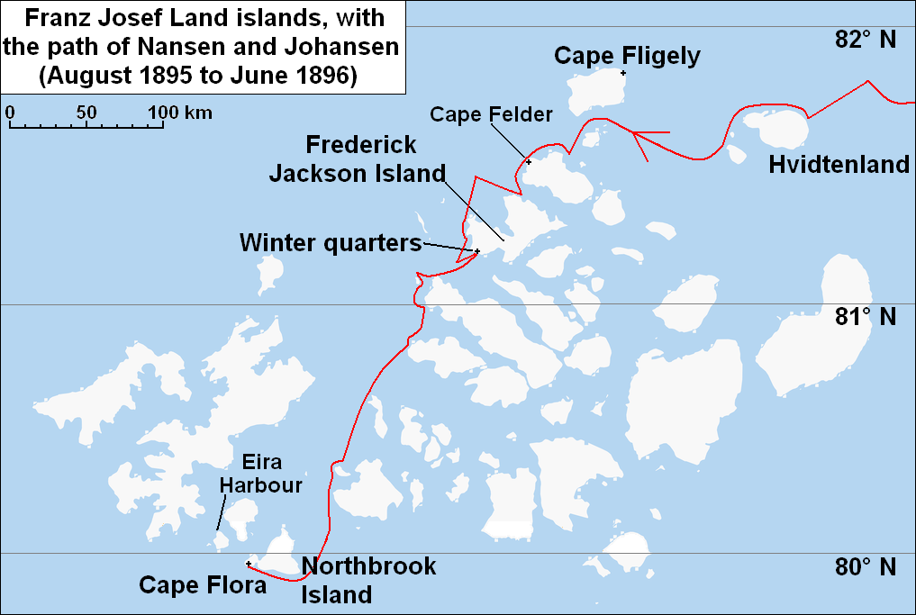
| Description | Map of w:Franz Josef Land archipelago in the Arctic Ocean north of Russia, showing the path of Nansen and Johansen through the islands, August 1895 to June 1896 |
| Date | |
| Source | Base map is cropped from http://www.openstreetmap.org/ , which is available under a "Creative Commons Attribution-Share Alike 2.0 Generic Licence" (or compatible for derivative works). The red line is based on map in Nansen, Fridtjof: Farthest North, Vol II, Constable & Co, London 1897, see w:File:NansenFranzJosefLandoldmap.jpg |
| Author | Open Street Map, Ruhrfisch |
| Permission (Reusing this file) |
|
| Other versions |
 |

|
File:Nansen Franz Josef Land voyage map.svg is a vector version of this file. It should be used in place of this PNG file when not inferior.
File:Nansen Franz Josef Land Voyage Map.PNG → File:Nansen Franz Josef Land voyage map.svg
For more information, see Help:SVG. |
 |
Licensing
I, the copyright holder of this work, hereby publish it under the following license:
This file is licensed under the Creative Commons Attribution-Share Alike Attribution-Share Alike 4.0 International, 3.0 Unported, 2.5 Generic, 2.0 Generic and 1.0 Generic license.
- You are free:
- to share – to copy, distribute and transmit the work
- to remix – to adapt the work
- Under the following conditions:
- attribution – You must give appropriate credit, provide a link to the license, and indicate if changes were made. You may do so in any reasonable manner, but not in any way that suggests the licensor endorses you or your use.
- share alike – If you remix, transform, or build upon the material, you must distribute your contributions under the same or compatible license as the original.
File history
Click on a date/time to view the file as it appeared at that time.
| Date/Time | Thumbnail | Dimensions | User | Comment | |
|---|---|---|---|---|---|
| current | 19:57, 11 October 2009 | | 1,017 × 683 (118 KB) | Ruhrfisch | Add Eira Harbour, Cape Felden labels, all other info the same |
| 14:32, 9 October 2009 |  | 1,017 × 683 (116 KB) | Ruhrfisch | Add approximate distance scale, all other information is the same | |
| 18:59, 7 October 2009 |  | 1,017 × 683 (116 KB) | Ruhrfisch | Added directional arrow, all other information is the same | |
| 18:02, 7 October 2009 |  | 1,017 × 683 (115 KB) | Ruhrfisch | Larger labels, latitude lines and Winter quarters added, all other information is the same | |
| 04:58, 7 October 2009 |  | 1,019 × 655 (49 KB) | Ruhrfisch | {{Information |Description = Map of w:Franz Josef Land archipelago in the Arctic Ocean north of Russia, showing the path of Nansen and Johansen through the islands, August 1895 to June 1896 |Source = Base map is cropped from http://www.opens |
File usage
The following pages on the English Wikipedia use this file (pages on other projects are not listed):